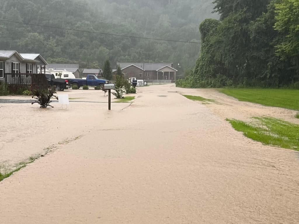
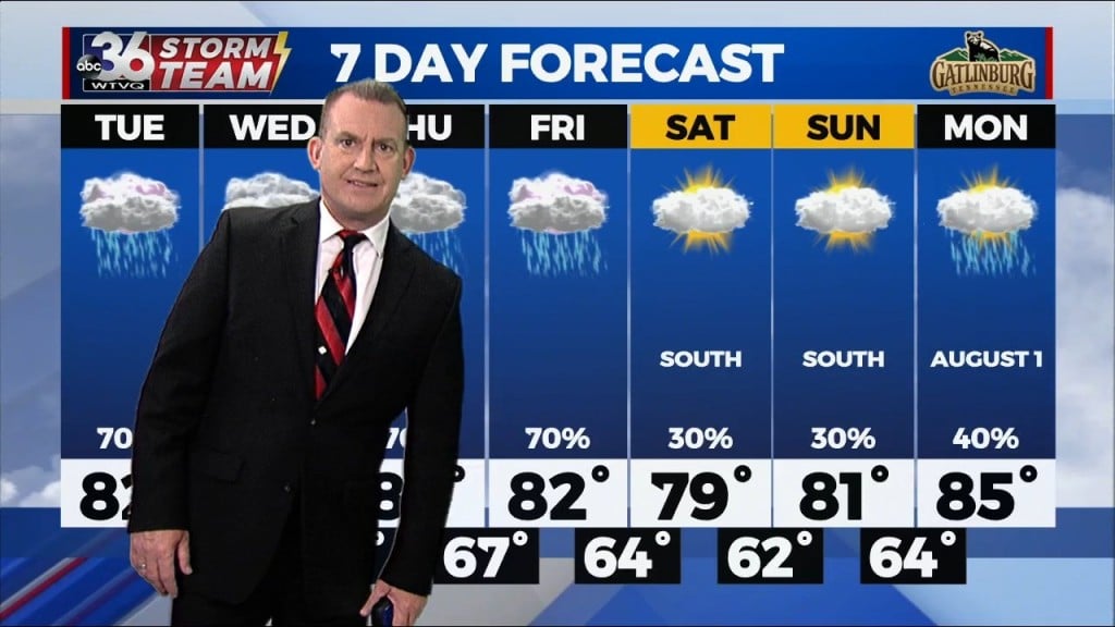
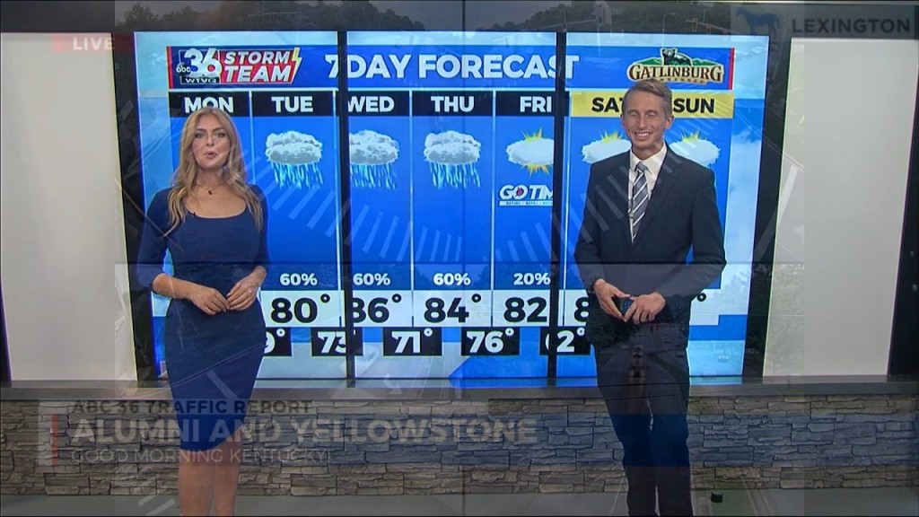
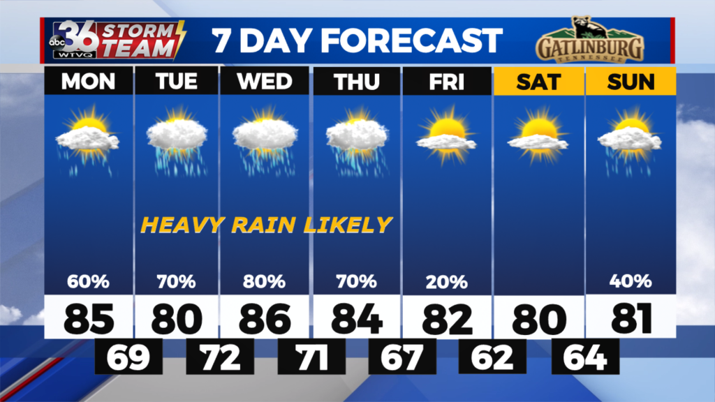
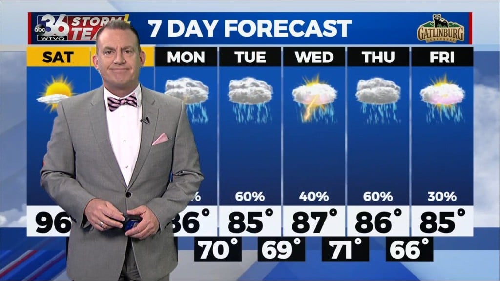
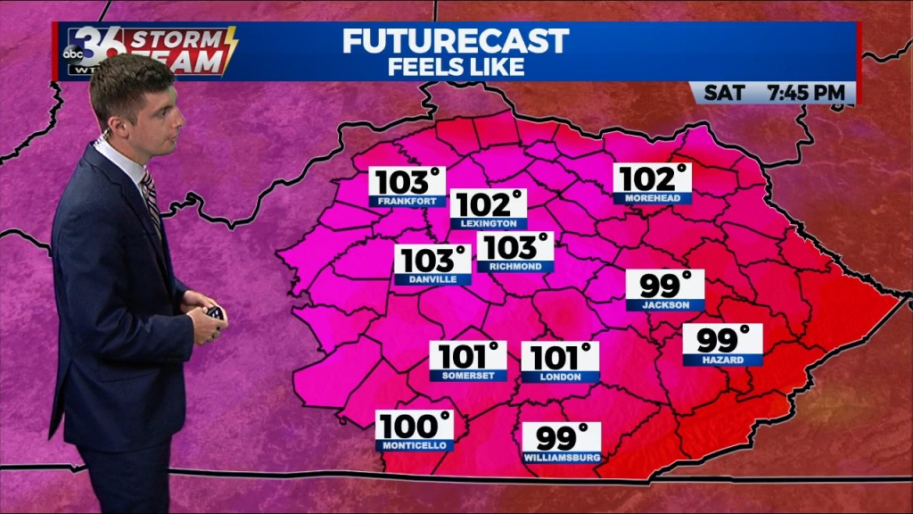
Heavy rain and flooding threat continues through the end of the week

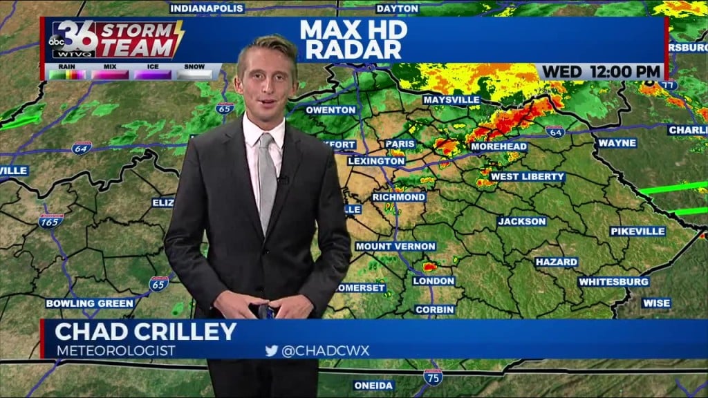
The same stationary boundary that has brought repeated rounds of showers and thunderstorms from the start of the week will continue impacting the region.

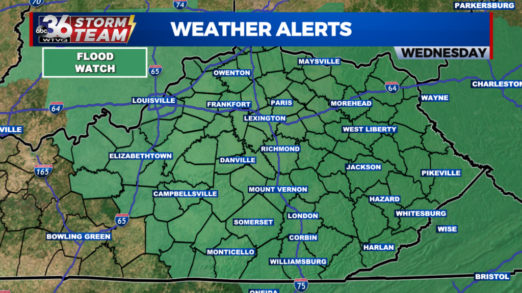
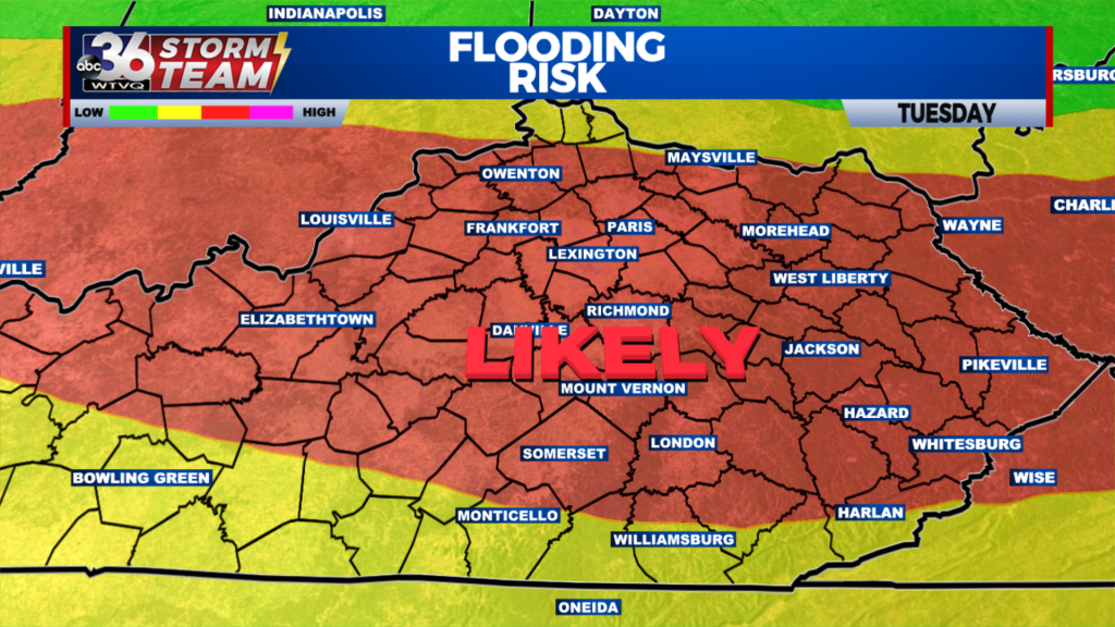
Rain was not as heavy or widespread Wednesday morning, and as a result, there have been fewer flooding issues. However, with our stationary boundary nearby and more rain expected, a Flood Watch remains in effect for the entire area through Wednesday evening. In addition to a flooding threat Wednesday afternoon, there is a low-end risk for an isolated strong or…

Scattered heavy rain leads to flooding concerns into the mid-week

With several more rounds of heavy rain and storms expected into Wednesday, a Flood Watch is out for all of Central and Eastern Kentucky until late Wednesday

We’ve dealt with a pretty dry summer across most of Central and Eastern Kentucky but Mother Nature is flipping the script on that thanks to a wet and unsettled weather pattern we’ve shifted into across the areas. Many locations in the Bluegrass saw 1″ plus rainfall totals on Tuesday with a few spots seeing 2″-3″ of rain. With additional rounds…

UPDATE: Victims identified in fatal wrong way crash in Laurel County

According to the London Police Department, it happened late Monday night

UPDATE: (1:50 P.M.)- The driver accused in the wrong way crash that killed three people appeared in court today, according to Laurel County District Court. Joshua Poore has been charged with three counts of murder and investigators believe Poore was drunk at the time of the crash. Poore has since been released from UK Hospital and is being held in…

Dangerous flooding possible this week in central and eastern Kentucky

A potentially dangerous setup is evolving over the next few days, with at least some flooding likely in central and eastern Kentucky.

A stationary boundary is set up over the heart of central Kentucky. The result has been several waves of heavy rain that have already produced Flash Flood Warnings across eastern Kentucky. A Flood Watch is in place for most of central and eastern Kentucky through Wednesday to address the possibility of flash flooding and flooding in rivers, creeks, and streams….

People in apartment displaced overnight after apartment fire in Lexington

According to the Lexington Fire Department, calls came in around 10:45 Monday night

LEXINGTON, Ky. (WTVQ) – Fire crews were out in downtown Lexington for several hours Monday night for a fire at an apartment building on West Second Street. According to the Lexington Fire Department, calls came in around 10:45 Monday night for reports of smoke coming from the attic of a three-story apartment building on the 400 block of West Second…

Unsettled weather pattern this week across Central and Eastern Kentucky

We'll see a much need break from the heat along with some drought busting rain with daily shower chances

It was a nice change of pace across Central and Eastern Kentucky to kick off the week. Gone was the full sunshine and big heat replaced with clouds, showers and storms and cooler temperatures. It was a gloomy day but at least afternoon highs were held in check with temperatures only topping out in the upper 70s and low 80s….

On and off showers and thunderstorms possible all week

A stationary front will set up over central Kentucky this week, bringing the return of showers and thunderstorms.

Showers and thunderstorms on Monday afternoon look to be most widespread across southern Kentucky. No severe weather is expected, but gusty winds and small hail are possible. The rain over the next few days will help to cool temperatures, but it will remain muggy since the front has yet to move through the region. We might see a break from…

Pool attendance triples during Lexington’s heat advisory

Southland Aquatic Center in Lexington saw at least 900 people per day over the weekend

LEXINGTON, Ky. (WTVQ) – Lexington’s been under a heat advisory for the majority of the last week. A lot of people using this time to hit up community pools in an effort to beat the heat and humidity. Lexington Parks and Recreation says Southland Aquatic Center is usually its busiest pool, seeing anywhere from 250-300 people per day. But, that…

Oppressive heat will end next week as rounds of showers and thunderstorms return

A stationary boundary will set up across central and eastern Kentucky next week, bringing on and off showers and thunderstorms.

On Saturday, a wave of energy passed across the Bluegrass State, bringing strong and severe thunderstorms to eastern Kentucky as it tapped into an unstable atmosphere. With the loss of daytime heating, expect a dry, warm, and muggy overnight. Sunday will be the last very hot day for some time. Temperatures will sore into the mid-90s, with the feels-like temperature…

The heat will be on this weekend across Central and Eastern Kentucky!

Highs will reach the low and mid-90s but at least humidity levels won't be off the charts.

With plenty of sunshine across Central and Eastern Kentucky, it was a hot finish to the week across Central and Eastern Kentucky as afternoon highs reached the low and mid-90s. The good news is that humidity levels stayed fairly low so it wasn’t horribly oppressive like this past Wednesday. The day started out beautifully once again with a gorgeous sunrise…

Hot and humid weekend on the way

More hot and humid weather is on the way this weekend ahead of an active pattern next week

Temperatures will be reaching the low-to-mid 90s by your Friday afternoon as we begin a hot and humid weekend across central and eastern Kentucky. Skies will be mostly sunny with no chance of rain to close out your weekend. Humidity won’t be quite as bad Friday, but we will start to see uncomfortable conditions Saturday and Sunday. Feels like temperatures…