Slightly cooler air for late March heading into the mid-week
The combination of clouds and a few showers should hold our temperatures in check a bit on Tuesday
We enjoyed a nice start to this final week of March across Central and Eastern Kentucky Monday despite a weak boundary and a wave of low pressure moving through the Ohio Valley. Most locations managed to avoid a few early morning showers with plenty of sunshine into the early afternoon before some mid-level clouds returned. That bonus sunshine helped afternoon highs to overachieve with most spots across the area topping out into the low and mid-60s.

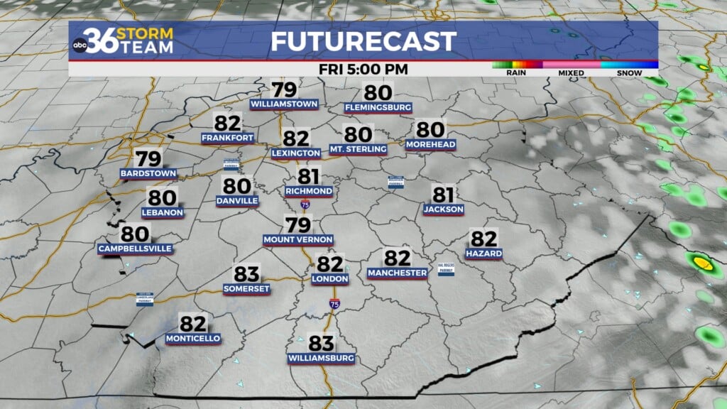
Our average highs have now worked back to 60 degrees (and climbing every few days) so we’ll take a small step back heading into Tuesday. A mid-level wave will cruise through the region on Tuesday with mainly cloudy skies by the afternoon and a few isolated showers possible as a result. These showers will be few and far between and most locations will remain dry. The combination of the clouds and spotty showers will hold afternoon highs in check with temperatures topping out in the low to mid-50s by the end of the day.

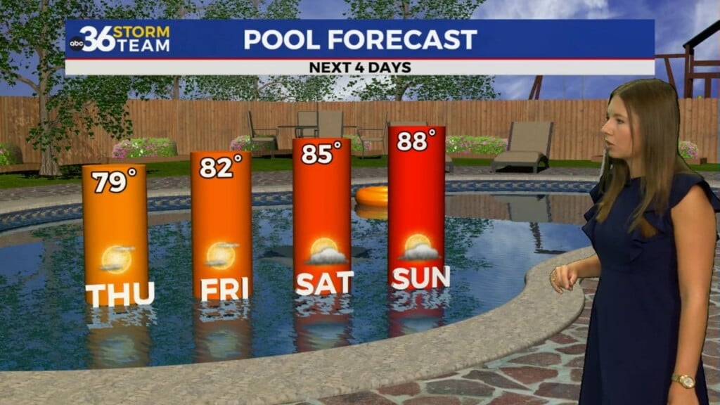
High pressure will build in behind the departing wave so skies should clear into early Wednesday, setting the table for another frosty morning across much of Central and Eastern Kentucky as temperatures dip into the upper 20s and low 30s. The growing season is starting to crank up thanks to the mild winter so you’ll want to protect any sensitive plants Wednesday morning (and Thursday mornings as well) with the cold temperatures expected. Of course the area of high pressure will provide some nice days through the mid-week with sunshine and highs in the upper 50s Wednesday before climbing into the mid-60s Thursday.

Another storm system will crank up into the Central Plains late this week with the potential for more rain (possibly heavy) and another round of gusty winds as we close out March Friday and kick off April into the weekend. Right now the best strong to severe storm threat looks to be to our west, but the Storm Prediction Center has areas Lexington westward in the “long range” severe weather risk for late Friday so this bears watching as the week wears on.

The potential for more heavy rain is on the table late Friday and into Saturday over already saturated ground, especially in Northern Kentucky. Yet again we’ll see some very gusty winds as the system departs the area with those 40 to 45 mile per hour gusts which have been so common with these wind events so far here in 2023. Stay tuned!

ABC 36 HOUR FORECAST
MONDAY NIGHT: A few clouds, breezy and chilly. Lows in the upper 30s.
TUESDAY: Mostly cloudy with isolated showers. Highs in the low to mid-50s.
TUESDAY NIGHT: Skies clear, a cold night. Lows in the upper 20s and low 30s.