Active weather cranks up to wrap up March
In addition to rain along with some possible strong storms into Friday night, another gusty wind event is on tap for Saturday!
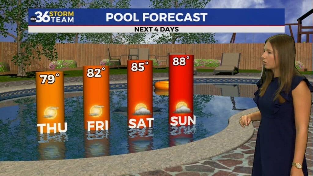
We’ve enjoyed a few delightful days across Central and Eastern Kentucky and Thursday was no exception thanks to high pressure building into the area. After another chilly start with readings into the mid-30s, full sunshine and a light southeast breeze helped push afternoon highs well into the 60s. You’ll want to soak up the tranquil conditions into Thursday evening as big changes are on the way the next few days.

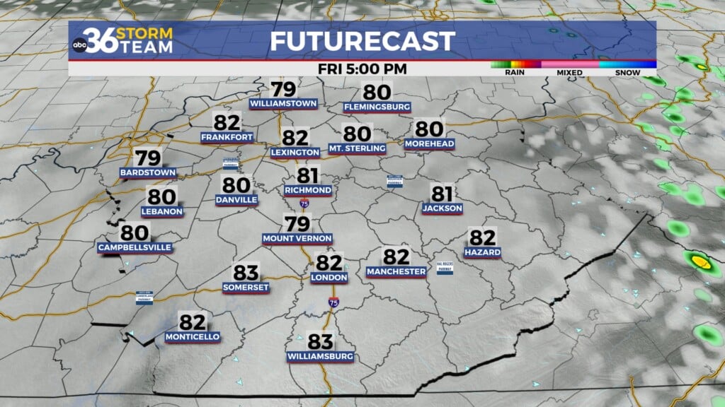
You’ll want to grab the umbrella head out the door on Friday as our next storm system brings several rounds of showers and thunderstorms to close out March and kick off April. While it shouldn’t rain all day, we’ll see a few waves coming through with a potential break in the action Friday evening before the main line of expected storms moves our way during the early hours of Saturday.


We still have the potential of a few strong to severe storms across Central and Eastern Kentucky as much of the data is showing the aforementioned squall line of thunderstorms rolling through ahead of the frontal boundary early Saturday. The Storm Prediction Center continues to have Eastern Kentucky in a Level 1 risk with Central Kentucky in a Level 2 risk (out of 5). The best set-up and dynamics for organized severe weather should remain out to our west as the line of storms develop late tomorrow. As the line moves eastward, the gusty/damaging wind threat will remain with an isolated tornado spin-up chance within the line as it approaches the I-75 corridor but should continue to weaken as it moves into Eastern Kentucky. The timing and set-up looks very similar to what was saw last Friday night and Saturday morning so just be prepared.


Once the rain clears out, the strong gradient winds will be the big story for Saturday, which has been a common theme across the Ohio Valley since early December. In fact this coming Saturday should be much like this past Saturday, with a few wind gusts over 50 miles per hour during the afternoon. Will we have a few scattered power outages? Probably. A few trees knocked down? Likely…but the key point is that this isn’t going to be an event like March 3rd with widespread issues. It should be more in-line with typical wind events the last few months. A Wind Advisory is expected into Saturday and this will be the 11th one issued since December 1st, when on average we see maybe 4 to 5 of those each year.

Our weather looks quiet on Sunday with sunshine and highs around 60 degrees before we see a major warm-up into the first week of April. With a strong southwest flow in place, temperatures should surge into the mid to upper 70s into next week so it will definitely feel like spring. This should help to officially kick start the growing season and may bring another strong to severe weather potential by the mid-week as another cold front moves through. Stay tuned!

ABC 36 HOUR FORECAST
THURSDAY NIGHT: Breezy with showers late, rising temperatures. Lows in the upper-40s.
FRIDAY: Breezy with occasional rain and storms. Highs in the mid to upper-60s.
FRIDAY NIGHT: Windy with more rain and storms, a few strong. Lows in the mid-50s.