Dry and warm to close out the week!
Enjoy it as our unsettled weather returns this weekend with scattered storms back in the picture.
With a frontal boundary dropping through the commonwealth on Thursday a few spots saw scattered showers and thunderstorms, mainly during the morning hours and mostly down south. With plenty of clouds around yet again, afternoon highs were held in check in many locations, topping out into the low 80s, which is roughly 5 degrees below average for this time of the year. A bit of hear should begin to build back in as we close out the week and head into the upcoming weekend.

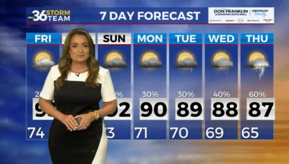
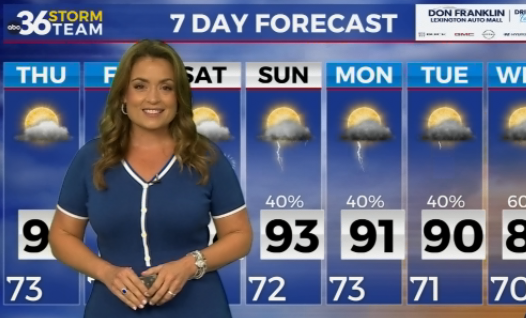
Friday looks like a good way to wrap up the week weather-wise as we stay mainly dry with much more sunshine than we’ve seen the last several days. Afternoon highs should recover into the mid-80s with a few spots even reaching the upper 80s, especially in the Lexington metro area. With a weak boundary to our south, some of the data is trying to fire up an isolated shower down south in the afternoon. While this is possible, it appears the majority of the area will stay dry.

Heading into the weekend, the warmth and humidity will continue to build as we see a return of a few scattered showers and storms. It shouldn’t be a washout so don’t cancel any outdoor plans. However on Saturday we could see a few stronger storms fire up so you’ll want to keep an eye on that. The Storm Prediction Center has a Level 2 severe risk (out of 5) from Lexington to the north and northwest with a Level 1 risk across South Central Kentucky. Damaging winds and hail will be the primary threats. Storms chances will continue into Sunday (to a lesser extent) as afternoon highs both days more a run into the upper 80s to around 90 degrees. There will be plenty of humidity and moisture around to help fuel the storms as our “muggy meter” stays high.


A stronger cold front will slide into the Ohio Valley on Monday keeping our rain and storm chances going. This front will be a big game changer into the middle of next week bring a quick shot of very pleasant air with sunshine, low humidity and comfortable highs in the upper 70s and low 80s Tuesday and Wednesday but getting there may be the issue. The Storm Prediction Center already has part of the region in the Extended Severe Weather Outlook for the possibility of strong to severe storms. Sure we are several days out, but this is something that bears watch over the next few days. We’ll keep you posted!


ABC 36 HOUR FORECAST
THURSDAY NIGHT: Mostly clear and mild. Lows in the mid-60s.
FRIDAY: Mostly sunny and warmer. Highs in the mid to upper-80s.
FRIDAY NIGHT: Mostly clear and quiet. Lows in the upper-60s.