Our weekend start mild for late January but our rain chances ramp up Sunday
Our active weather pattern will continue into the final days of January with more wintry weather possible next week
It turned out to be an interesting start to Friday across the Northern Bluegrass Region including north Lexington and up into Scott County as a narrow band of early morning snow followed by clearing skies and temperatures in the 20s created a proverbial skating rink with icy roads during the morning commute. Parts of I-75/I-64 in Lexington was closed for a period of time before sunshine coupled with a strong south wind pushed afternoon highs into the mid-40s to close out the week.


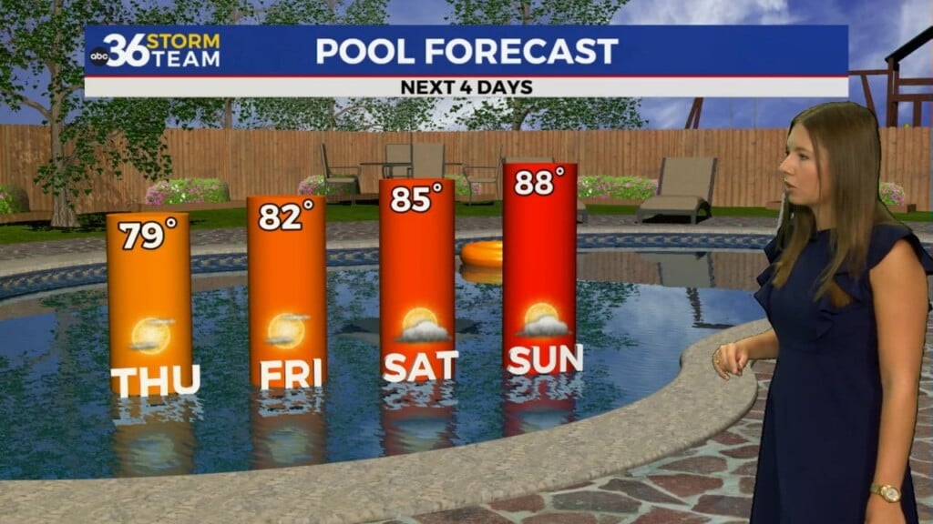
The final Saturday of January looks pretty ideal across Central and Eastern Kentucky thanks to high pressure to our southeast. The combination of sunshine and a strong southwest wind will push afternoon highs well into the 50s across the board so you’ll want to get out and enjoy it while it lasts!

A frontal boundary will drop into the Ohio Valley quickly on Sunday, setting us up for a very damp finish to the weekend. Expect the rain to ramp up in coverage and intensity into the early part of Sunday with solid rain through the morning hours before the activity tapers off through the afternoon. Everything should be in the liquid form with highs in the upper 40s and we could see maybe a half of an inch to 3/4 of an inch of rainfall out of this system.


Heading into the final few days of January and kicking off February our active and wintry weather pattern should kick back in. Other than some patchy drizzle or a passing shower, Monday looks dry before our set-up begins to favor more wintry weather into the middle of next week. Right now it appears a few waves of low pressure will pass by to our south and with high pressure to our northwest, we may see warmer air on top of colder air at the surface across parts of the area. This generally brings the freezing rain potential into play in our area. Per usual, a few miles could make a difference in precipitation type but luckily this system is several days away as the model data tries to get a handle on it. It should end as some snow as colder air comes back later next week. We’ll keep an eye on it!


FRIDAY NIGHT: Partly cloudy and breezy. Lows in the mid-30s.
SATURDAY: Mostly sunny, breezy and milder. Highs in the mid-50s.
SATURDAY NIGHT: Clouds increase, rain returns. Lows in the low 40s.