Cloudy and chilly rolling into Groundhog Day
After a wintry and unsettled finish to January, quiet and chilly weather should stick around for the few few days of February
It was an active finish to January with several rounds of wintry weather across Central and Eastern Kentucky, including a few slick roads down south to kick things off on Wednesday. Luckily we saw some much needed sunshine across the area before additional clouds rolled in late in the day. Even with the sunshine, afternoon highs hovered right around the freezing mark, but then brief sunshine did help melt some of the light ice accumulations on trees and power lines.

Heading into Groundhog Day, another wave of energy will slide by to the south of Kentucky but this one should be far enough away to keep any wintry precipitation confined to areas along the Kentucky/Tennessee border at best. With the clouds around, there shouldn’t be any shadows for area groundhogs in our neck of the woods so hopefully that means that spring is right around the corner. Ironically Mother Nature may follow suit with more spring-like weather soon, but more on that in a bit. We may see some sunshine late as temperatures check up into the upper 30s to around 40 degrees.

A dry cold front will slide through the commonwealth early Friday, bringing much needed sunshine to wrap up the week but also much colder air even though it won;t stick around long. With high pressure to our northwest, a very cold air-mass will drift in and hold afternoon highs into the upper 20s despite the expected sunshine. The good news is that the cold air won’t hang around long as the area of high pressure slides to our east allowing a southeast flow to kick in. As a result, highs should jump back into the mid-40s to kick off the weekend and that will be a prelude of things to come.

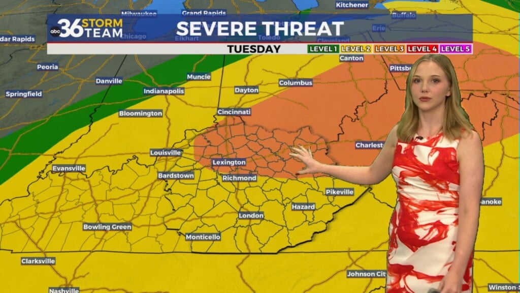
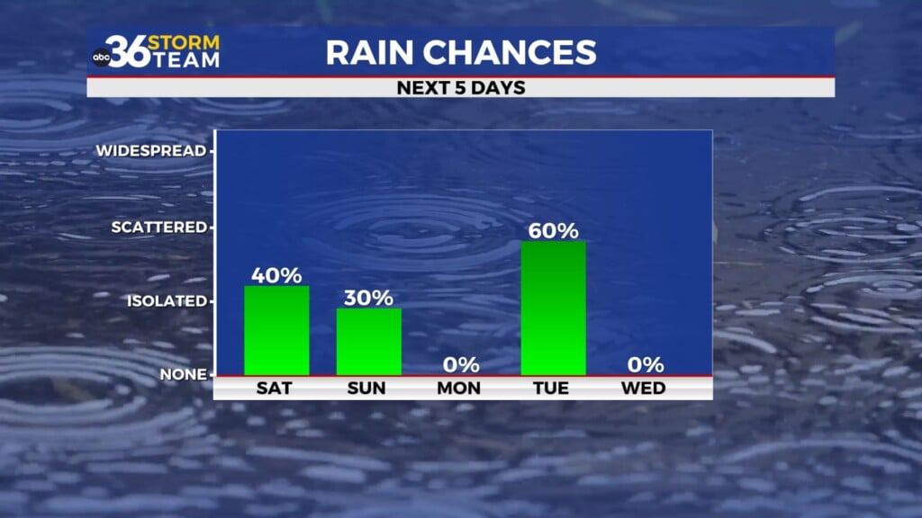
Another round of spring-like weather will kick in for Sunday and beyond as a southwest flow brings unseasonably mild air into the region. Temperatures should surge into the upper 50s to near 60 degrees into early next week as a cold front approaches next Tuesday and into Wednesday. The precipitation will firmly be in the liquid form with temperatures well above average for early February.


WEDNESDAY NIGHT: Mostly cloudy and cold, a wintry mix far south. Lows in the upper-20s.
THURSDAY: More clouds and still cold. Highs in the mid to upper-30s.
THURSDAY NIGHT: Scattered clouds and breezy. Lows in the low-20s.