Humidity increases as the dry weather continues into Saturday
Scattered shower and storm chances look to return to end the weekend
We’ve enjoyed an incredible stretch of weather for the first week of June across Central and Eastern Kentucky and we capped it off in style with another delightful late spring day on Friday. With high pressure still in control to our southwest, the dry weather stayed put across the commonwealth. The combination of sunshine and high clouds along with a breezy southwest wind helped push afternoon highs into the mid-80s across the board so it was another good day to be out and about.

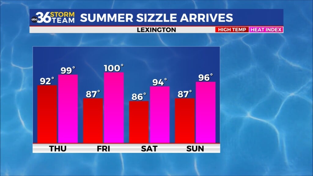
The quiet weather pattern looks to hang on for one more day as we kick off the weekend with some subtle changes kicking in. The steady to breezy southwest wind will help push additional moisture into the region so for the first time in several days the humidity levels will be more noticeable. We’ll catch enough of high pressure to our southeast to keep things dry in most spots despite a weak front dropping in from the northwest. With more sunshine around, afternoon highs will reach the mid to upper-80s so you’ll need to hydrate and take it slow during the hottest part of the day for any outdoor plans you may have given the increase in the muggy air. And that includes the Railbird Festival going on out at the Red Mile in Lexington this weekend.


Closing out the weekend our chances for scattered showers and storms will be on the rise as the aforementioned frontal boundary slides a little farther to the south. With plenty of warm and muggy air in place, the shower and storm chances will pick up through the day on Sunday so you’ll need to keep that in mind and give the weather a quick check relative to anything outdoors. We could see some locally heavy downpours even if the activity isn’t expected to be widespread. With the front camped over the commonwealth and some subtle waves of energy riding along it, look for a repeat performance early next week with more rain and storms possible into Monday. Afternoon highs will still be in the mid to upper 80s despite more clouds and occasional showers around.


Look for more of a summer-like pattern through much of next week as the warm and muggy air stays in place across the Ohio Valley. The frontal boundary will hang around into the mid-week as it slowly weakens but with all the moisture in place over the commonwealth more showers and storms will be possible. Most of the activity will be primarily driven by the warmth/heating of the day so the best chances look to be during the afternoon and early evening hours especially later in the week, which is more typical of what we see during the heart of the summer season. Afternoon highs each day should be in the upper 80s to near 90 degrees, which is a few degrees above average even for early June.


ABC 36 Storm Team 3 Day Forecast
Friday night: A few clouds and mild. Lows in the mid-60s. Wind: SW 5-10 mph.
Saturday: Mostly sunny, breezy and warm. Highs in the mid to upper-80s. Wind: SW 10-15 mph.
Saturday night: Partly cloudy and muggy. Lows in the upper-60s. Wind: SW 5-10 mph.