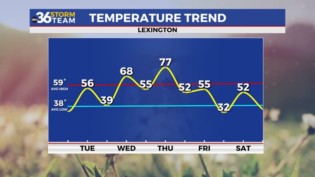
Active and unsettled weather pattern sticks around
A few strong storms may be possible into the early hours of Tuesday as a thunderstorm complex moves in
We definitely saw some beneficial rains on Sunday across much of Central and Eastern Kentucky as the moisture return from the Gulf of Mexico. Of course overall totals varied with a few spots picking up well over 1″ with others much lower than that. The good news is that most everyone saw some much needed rainfall given the dry conditions across the area and the unsettled pattern continued on Monday. Additional rain and storms dotted the landscape with some localized heavy downpours once again. You could really feel the humidity in the air as dewpoints surged into the low to mid-70s giving us that tropical feel in late July while afternoon highs were held in check into the low to mid-80s with the clouds and storms around.

More active weather is expected into the early hours of Tuesday as a complex of thunderstorms if forecast to develop just to our northwest mid to late Monday evening and fan out across the area during the overnight hours. The Storm Prediction Center has much of Central Kentucky in a Level 2 severe risk (out of 5) with a Level 1 into Eastern Kentucky. Damaging winds along what could be a squall line look to be the primary threat, but there is a low end spin-up tornado threat as well. At this point the more favored area should be in Southern Indiana with any isolated supercells cranking up before the main area of strong storms moves in. Torrential rain is possible some a few flooding issues may be realized during the overnight so keep that in mind.


As you know the most dangerous time for any type of severe weather is during the late evening and overnight hours so it’s a great time to download the NEW ABC 36 Weather app. This has the latest technology for weather apps and most importantly for tonight’s storm potential gives you customized severe alerts, including when a storm is located within 25 miles of your location and lightning is within 15 miles of your locations in addition to all the normal warnings, watches and advisories. It has real-time interactive radar and has a future radar that gives you an idea what the storm will do 2 hours into the future. Search “ABC 36 Weather” in the App Store or Google Play to download it.

The unsettled pattern will stay in play and we deal with pretty typical late July heat and humidity to close out the month. With several clusters of thunderstorms set to develop in the upper level flow out of the northwest and drop into the Ohio Valley, more storm chances will be possible into the mid-week. The biggest challenge will be the timing and placement of these clusters which will have an impact of afternoon highs and the amount of rain we inevitably see. There will be lots of available moisture as the “muggy-cast” indicates so it won’t take much to get some heavy rain producing storms going. Away from storms, expect a hot and humid stretch with highs into the low and mid-90s later this week, especially as the rain chances back down. Heat index values coupled top the 100 degree mark at times later this week so be prepared for that.


Heading into the first weekend of August a weak boundary should drop in from the northwest late on Friday ushering in some “slightly” milder and drier air. At this point the weekend is trending drier compared to how things looked a few days ago. Temperatures will still be warm to hot but by Sunday it should feel pretty decent for the early part of August with highs in the upper 80s to right around 90 degrees.

ABC 36 HOUR FORECAST
MONDAY NIGHT: Muggy with scattered storms, some strong. Lows in the low-70s.
TUESDAY: Hot and humid with a few storms. Highs in the low-90s.
TUESDAY NIGHT: Warm and muggy, more scattered storms. Lows in the low-70s.