Nice weather for late June into the mid-week
Showers and storms look to return heading toward the weekend
After an unsettled start to the week with some heavy rain causing some localized flooding issues in a few locations, it was a less active Tuesday across the region as high pressure pushed drier air into the region. Location was key as a north breeze brought mainly sunny and pleasant conditions to Central Kentucky, while some leftover moisture in the southeastern mountains kept a few scattered showers around during the morning hours. The drier air won out across the board later in the day with pleasant temperatures for late June as afternoon highs reached the upper 70s in most spots.

Look for a delightful Wednesday all across Central and Eastern Kentucky as the area of high pressure settles southward through the Ohio Valley. After starting the day with temperatures in the mid to upper-50s, we should enjoy a nice warm-up area wide with plenty of sunshine expected. Winds will be light but the general flow will shift to the southwest as high pressure drifts to our east. This will push some slightly warmer air into the region with temperatures climbing into the low-80s for afternoon highs.


Rolling into the late week, a frontal boundary will drop into the Ohio Valley from the northwest increasing our chances for scattered showers and thunderstorms beginning Thursday. With plenty of moisture returning to the commonwealth thanks to the southwest flow, any showers and storms that pop up have the potential of producing some locally heavy rain. Overall it shouldn’t be a wash-out as afternoon highs reach the mid-80s. A wave of energy will rotate in from the northwest on Friday as the front stalls out over the commonwealth, so look for a better chance of more widespread rain and storms. The concern of course will be the slow movement of any storms given the lack of upper level winds along with the “training” over heavy rain over the same areas, which may lead to some additional flooding concerns.


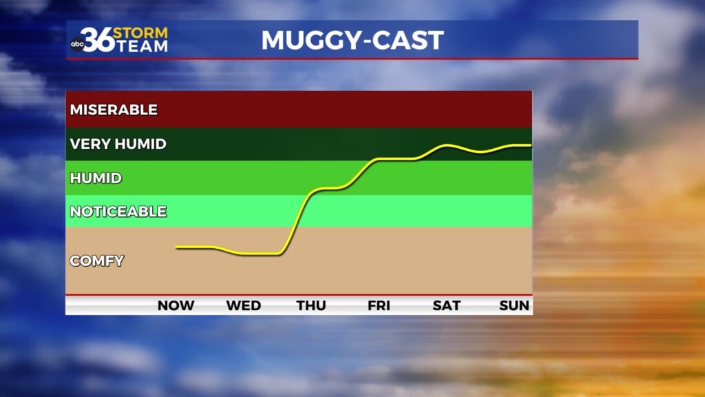
The stalled out front should still be hanging over our area as we kick off the weekend so look for more rain and storm chances on Saturday. Any outdoor plans may need to be adjusted given the legitimate rain chances. It will be a warm day despite the showers expected with highs into the low to mid-80s. The data is still hinting at an upper level ridge building into the region beginning Sunday and into early next week. This would help push the stalled out front off to our north and put us into a more summer-like pattern with heat and humidity returning to the commonwealth. Look for temperatures to climb back into the low-90s for highs early next week and with some muggy air in place, our “feel-like” temperatures during the afternoons could make a run toward the century mark.


ABC 36 Storm Team 3 Day Forecast
Tuesday night: Mostly clear and pleasant. Lows in the upper 50s. Wind: NE 5 mph.
Wednesday: Mostly sunny and warm. Highs in the low-80s. Wind: SW 5 mph.
Wednesday night: Fair skies and quiet. Lows in the low-60s. Wind: SW 5 mph.