Hot and humid into the late week
With mainly dry weather, heat indices should climb into the upper 90s
We got a break from the active and wet weather pattern on Wednesday across much of Central and Eastern Kentucky following the significant rainfall here in the Bluegrass Tuesday. Fortunately the early morning thunderstorm complex stayed mainly north of our area, sparing us from more flooding rain potential. With a mix of clouds and sunshine through the day, temperatures climbed into the upper 80s for afternoon highs and with the elevated humidity levels in place, it felt more like the mid-90s at times. This summer-like set-up should continue into the late week.

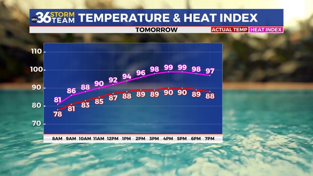
While more mainly dry weather is on the way for Thursday (other than a stray storm across the north), the concern will be for the unseasonably hot and humid conditions expected through the day. With plenty of sunshine around, afternoon highs will surge toward the 90 degree mark in most locations. Given the tropical air-mass that should be hanging over the area with higher humidity levels, our “feel-like” temperatures could climb into the upper 90sn to around 100 degrees. This is the first time all year we’ve had to deal with elevated heat indices so you’ll definitely want to slow it down during the hottest part of the day and hydrate properly if you have to be outdoors for any length of time. One thing that may help is a breezy southwest expected, which will keep the air mixed up and hopefully take the edge off the heat a bit.


Our break from the stormy weather won’t last long as another cold front drops into the area on Friday so you’ll need the rain gear to close out the week. Scattered showers and storms should be on the table with some locally heavy rain on tap given all the moisture around. Afternoon highs should only reach the low to mid-80s with the clouds and rain around. This frontal boundary will slide to the south heading into Saturday and essentially sweep a good bit of the moisture out of the region so look for a quick break from the muggy conditions. It should be great timing for outdoor activities on Saturday as dry and comfortable weather is expected. With plenty of sunshine and lower humidity levels, afternoon highs should reach the mid-80s so you’ll want to enjoy the nice conditions for mid-June while they last.


Our roller coaster ride of weather should continue for the second half of the weekend as the rain and storm chances pop back into the commonwealth quickly thanks to yet another frontal system arriving from the northwest. Sunday should feature additional rain and storm chances so clearly you’ll want to squeeze those outdoor weekend plans in on Saturday. The front is expected to slow down and stall out over the area into early next week so we’ll be dodging a few showers and storms during that window. With a bit of a trough digging through the Great Lakes and into the Ohio Valley, temperatures won’t be quite as warm during the period with afternoon highs only in the upper 70s to around 80 degrees for a few days next week.

ABC 36 Storm Team 3 Day Forecast
Wednesday night: Fair skies, warm and muggy. Lows in the low-70s. Wind: SW 5-10 mph.
Thursday: Mostly sunny, hot and humid. Highs in the upper-80s to around 90 degrees. Wind: SW 10-15 mph.
Thursday night: Partly cloudy, still warm and muggy. Lows in the low to mid-70s. Wind: SW 5-10 mph.