Rain back around to close out the week
We may finally see a brief break from the wet pattern with some sunshine returning by Sunday
Sunshine has been at a premium the last few days where in Central and Eastern Kentucky on Thursday was no exception. With lots of low moisture in place, it was another mostly cloudy day as the dreary weather stayed put. We did manage to finally break out of the mid-40s here in the Bluegrass, where we had been camped out for more than a day thanks to a light southwest flow pushing “milder” air into the region. As a result, afternoon highs climbed back into the low to mid-50s across Central Kentucky with upper 50s and low 60s down south. A few showers crept back into the area from the southwest to northeast into the afternoon hours, which will be a prelude of things to come to finish out the week.

You’ll definitely need the umbrella from time to time on Friday as a wave of low pressure spins through the commonwealth. The exact track of the low will be a big determining factor with temperatures and the amount of rain we receive. A track farther north would allow milder temperatures into the 60s and a little less coverage with the showers while a track farther south would keep things a touch cooler and a bit wetter throughout the day. Either scenario will have Friday as an unsettled weather day so look to dodge some rain on occasion. Of course the wet conditions look to impact round 3 of the high school football playoffs Friday night so keep that in mind.


The area of low pressure will be on the way out as we kick off the weekend so look for a few lingering showers Saturday morning before the rain chances wind down through the afternoon. We aren’t looking at any big push of cooler air behind the departing low so temperatures should remain pleasant for this time in November as afternoon highs reach the upper 50s. It looks like Sunday will be the pick day of the weekend (and even the extended forecast) as high pressure builds into the Ohio Valley. It will definitely be the best day for any outdoor activities you may have planned with plenty of sunshine on tap and above average highs remaining in the upper 50s to around 60 degrees.

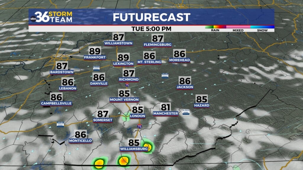
The break from the unsettled weather won’t last long as more clouds and another storm system looks to head out way rolling into Thanksgiving week. Clouds will be on the increase Monday and depending on your model of choice, a few showers could sneak in before the end of the day. The better chance for another round of rain arrives on Tuesday so the rain gear will continue to get a workout like it has lately. The shower chances may linger into the big travel day next Wednesday before another legitimate cold front drops through the region into Thanksgiving with some additional chilly air as highs struggle into the 40s to begin the long holiday weekend.


ABC 36 Storm Team 36-Hour Forecast:
Thursday Night: Light rain with steady/rising temperatures. Lows in the low to mid-50s early. Wind: SE 5 mph.
Friday: Occasional rain, some thunder. Highs in the mid-60s. Wind: S 5-10 mph.
Friday Night: More clouds and showers. Lows in the lo-50s. Wind: NW 5-10 mph.