More showers and storms possible into the late week
You'll need to take the rain gear along on Thursday
After a return of some much needed showers and storms across the area on Tuesday even though the activity was scattered, much of Central and Eastern Kentucky remained dry on Wednesday with a mix of clouds and sunshine across the area. The mid-level wave responsible for driving the pulse-type storms worked its way eastward so we did see a few additional showers and storms fir up through Wednesday afternoon, mainly into Eastern Kentucky. It was another pleasantly warm day with afternoon highs in the low 80s, which is right where we should be for early September.

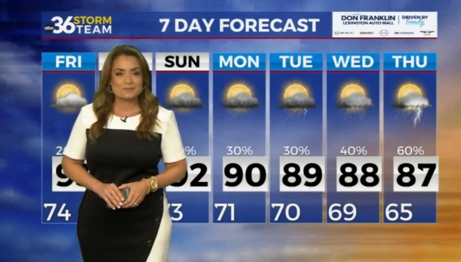
A cold front will slide in from the northwest on Thursday bringing a better chance for widespread showers and storms across the region. While totals aren’t expected to be overly high and unfortunately shouldn’t be enough to knock back the recent drought conditions that have set in, we could see a quarter to half inch of rain for many locations with a few spots receiving a bit more than that. With the expected clouds, scattered showers and the passing front, temperatures will be a bit cooler with afternoon highs backing down into the mid-70s. There is a low end chance of a few strong storms across Southeastern Kentucky as the Storm Prediction Center has a Level 1 (out of 5) severe weather risk for Thursday afternoon.


Closing out the week on Friday, we’ll be in between frontal boundaries with sunshine expected to be back around to close out the week. With a southwest flow ahead of the next cold front, afternoon highs should surge back into the mid-80s so it looks to be a warm day. Right now it appears the best chances for organized rain and storms will be late Friday night and into Saturday morning so hopefully we can get high school football games in without any impact Friday evening. Looking ahead to Saturday, the rain chances should stick around through the morning hours and could linger into the early afternoon, which would impact tailgating for Kentucky’s game against Ole Miss at 3:30pm Saturday over at Kroger Field. The data is still showing the rain chances should be winding down as drier air works in mid to late afternoon so the later kickoff is an advantage for things being dry during the game. Cooler air will be filtering in so it will feel like football weather as afternoon highs only reach the low 70s!


Another area of cooler Canadian high pressure will build in for Sunday so the end of the weekend looks delightful with sunshine, low humidity levels and very pleasant temperatures. Afternoon highs should only top out in the mid-70s so it should be a great day to enjoy any outdoor activities. The nice weather will carry over into Monday before an inverted trough to the south tries to throw some moisture and a low end shower chance our way for Tuesday, although the drier air may inevitably win out.


ABC 36 Storm Team 36-Hour Forecast:
Wednesday Night: Partly cloudy, a few storms late. Lows in the low-60s. Wind: SW 5-10 mph.
Thursday: Scattered rain and storms. Highs in the mid-70s. Wind: W 5-10 mph.
Thursday Night: Drying out and pleasant. Lows in the upper-50s. Wind: S 5 mph.