More comfortable weather into Thursday as the back and forth continues
Once again a brief break from the heat and humidity is on the way into the late week
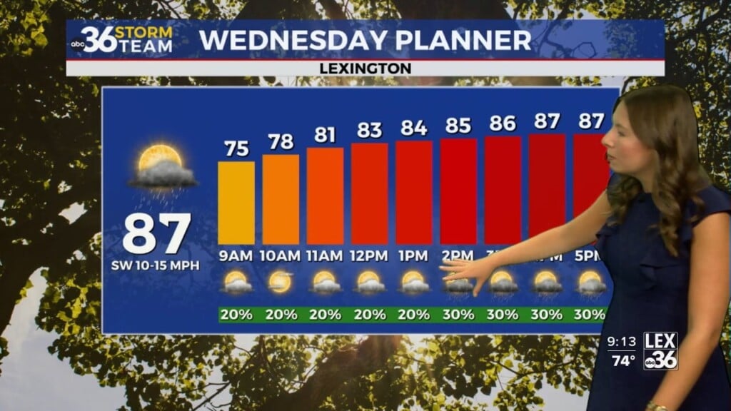
It was a warm and muggy Wednesday across Central and Eastern Kentucky as you could really feel the thick, moist air as humidity levels and dewpoint temperatures felt more like the heart of the summer season. With a cold front approaching from the west the threat for scattered storms, some of which could be strong will hang around through the evening hours until the front clears. One thing that played to our advantage much of the day was some mid to high level cloudiness especially here in Central Kentucky which limited our warm-up and slowed sown the thunderstorm development, while the extra sunshine helped storm fire more efficiently in the southeast. Highs reached the mid-80s in the Bluegrass while far southeastern Kentucky did manage to spike up into the upper 80s to around 90 degrees.

High pressure will build in behind the front quickly on Thursday setting us up for a delightful day. With a fresh north to northeast breeze bringing in drier air, expect lower humidity levels which will help make it feel much more comfortable outdoors. Afternoon highs should reach the mid-80s which is right around average for late June and coupled with the sunshine should provide a really nice day overall.

You’ll definitely want to enjoy Thursday and the heat and moisture roll back into the commonwealth to close out the week Friday and head into the upcoming weekend as the back and forth weather pattern holds serve. Friday looks mainly dry as temperatures surge back into the low 90s for highs. A frontal boundary will drop into the area late Saturday and into Sunday increasing our rain and storm chances for the final weekend of June. We’ll have to watch for the potential of a few strong storms Saturday night as well. The “muggy-cast” continues to show the up and down pattern of humidity levels with a big surge of moisture ahead of the weekend system, which isn’t necessarily a bad thing considering the need for rain around the area.


Another shot of more pleasant air will greet us as we welcome July on Monday. Temperatures should feel really good with highs in the low to mid-80s but you know this time of the year the unseasonably “mild” air won’t last long. Much of the data indicates that temperatures will continue to be above average in our region through the 4th of July holiday week, which would put us at least in the lower 90s for afternoon highs.


ABC 36 HOUR FORECAST
WEDNESDAY NIGHT: Storms ending, drying out. Lows in the mid-60s.
THURSDAY: Mostly sunny, less humid. Highs in the mid-80s.
THURSDAY NIGHT: Mostly clear and pleasant. Lows in the low-60s.