Hottest day of the year possible Friday across Central and Eastern Kentucky
A Heat Advisory is out for the entire area Friday as heat indices could reach between 100 and 105 degrees with temperatures in the mid-90s
Despite all the big heat across parts of the country for an extended period of time this summer, we’ve largely avoided any significant heat across Central and Eastern Kentucky but that has changed the last few days. It was another hot and humid day with afternoon highs in the low 90s with heat indices topping the 100 degree mark in several locations. This will be a prelude of things to come to close out the week and head into the upcoming weekend. A few scattered storms will be possible late Thursday evening and into early Friday with some heavy rain and gusty winds possible.

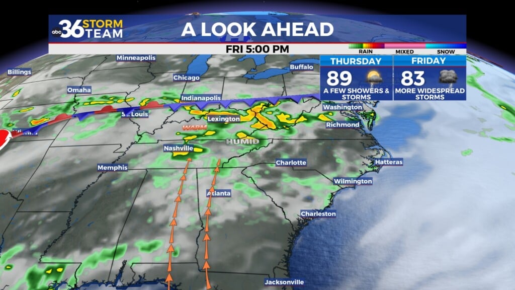
The bubble of high pressure and heat will strengthen on Friday allowing temperatures to crank up efficiently. Afternoon highs will reach the mid-90s, which would be our hottest temperatures across the area so far this year. With humidity levels high and dew-points feeling like the tropics, heat indices will be problematic. With the heat index expected to be closer to 105 degrees in several spots, a Heat Advisory is out for the entire area from 11am to 10 pm. You’ll definitely want to use some common sense and take the proper precautions to avoid any heat related illness. Just stay inside and find some good A/C if you can.


Heading into the weekend, a boundary will drop in from the north increasing our chances for a few storms late in the day. Before that it will be another hot day with highs in the low to mid-90s and heat indices above 100 degrees. With it being a weekend day, make sure and hydrate well if you have to be outside for any length of time. The good news is the front will move through Saturday night and into Sunday, providing some relief from the big heat. After a few storms into Sunday, high pressure will bring less humid and slightly cooler air in as we close out July on Monday and kick off August on Tuesday. You can see how the “muggy meter” take a tumble late in the weekend so that’s something to look forward to. Stay cool out there!


ABC 36 HOUR FORECAST
THURSDAY NIGHT: Warm and muggy, a few storms. Lows in the mid-70s.
FRIDAY: Very hot and humid, heat indices 100 to 105 degrees. Highs in the mid-90s.
FRIDAY NIGHT: Mostly clear with isolated storms. Lows in the mid-70s.