Wintry weather winds down into the late week
Additional snow showers are possible into early Thursday
The winter storm that impacted the region overnight and into Wednesday morning has moved out, leaving behind 2 to 4 inches of snow across much of Central and Eastern Kentucky. The heaviest snowfall occurred south of I-64 where some isolated totals approached 5 inches. Through the late morning and early afternoon we managed to see a bit of sunshine from time to time, which helped road crews with clearing the snow. Travel conditions improved throughout the day but temperatures remained in the low 20s. Add in a gusty north winds and our feel like temperatures were well into the single digits much of the day.


Bitter Cold and Another Round of Snow Tonight
As Arctic air continues to settle in, temperatures will plummet into the single digits overnight, with wind chills dropping as low as -5°F to -10°F by Thursday morning. With these frigid temperatures, any wet or slushy roads will quickly refreeze, creating black ice concerns for the morning commute. With the dangerous wind chills expected, a Cold Weather Advisory remains in effect for the entire region through 11 am Thursday morning so bundle up.


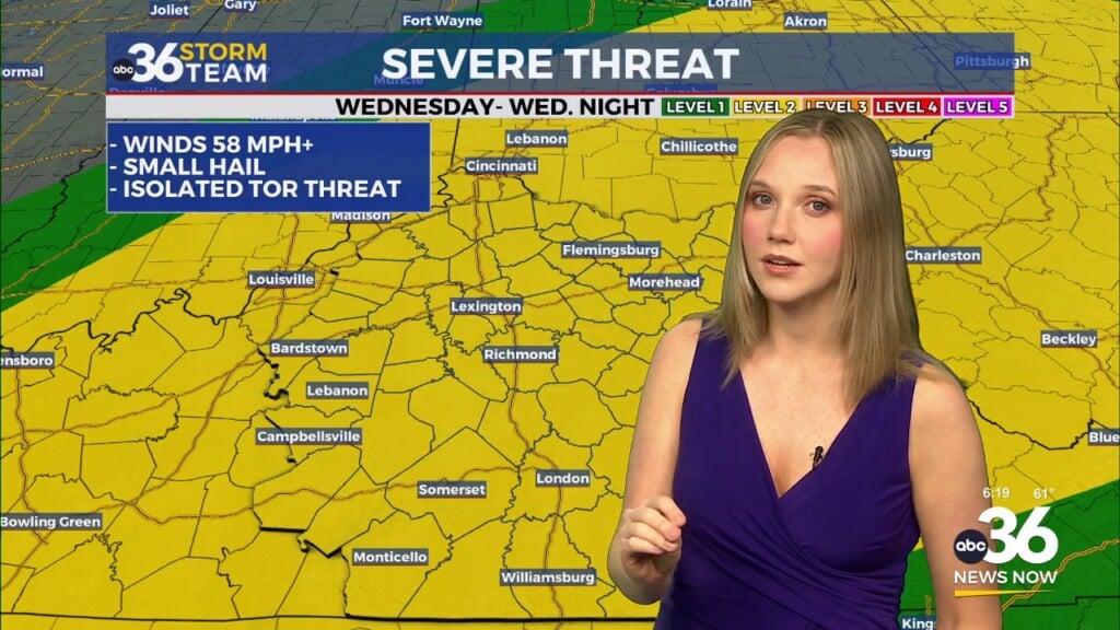
Adding to the challenges, a fast-moving upper-level disturbance will bring another round of light snow late tonight and into early Thursday morning. A Winter Weather Advisory is in effect until 7:00 AM Thursday with a Winter Storm Warning continuing in the eastern mountains. We could see up to an inch of additional snow possible so keep that in mind. While accumulations will be much lighter than last night’s storm even a dusting of new snow on top of frozen roads will create treacherous travel conditions overnight and into the Thursday morning drive.


Looking Ahead – Arctic Air Holds Strong, But Warmer Days Are Coming
Thursday will start very cold, with a few lingering morning flurries are possible, but most of the day will be dry and partly sunny. However, temperatures will struggle to reach low-20s, keeping everything frozen.
Friday remains cold but quiet, with mostly sunny skies and highs in the upper 20s. While that’s still well below normal, a gradual warming trend will finally begin over the weekend.
By Saturday, highs will return to the mid-30s, and by Sunday, temperatures will climb into the 40s. A few clouds will increase late in the day, but no major weather systems are expected.

Early next week, the warming trend continues, with highs in the upper 40s to near 50°F by Monday and Tuesday. Overnight lows will remain chilly, but daytime conditions will feel much more manageable compared to the bitter cold we’re dealing with now. By midweek, a system could bring rain back to the area, but temperatures should remain above freezing, meaning no winter weather concerns for the first half of the week.


ABC 36 Storm Team 3-Day Forecast:
Wednesday night: Snow showers return, an additional 1″ or so of accumulations. Frigid wind chills. Lows in the low teens.
Thursday: Morning snow showers then partly sunny. Highs in the low-20s
Thursday Night: Mostly clear and bitterly cold. Lows in the low to mid single digits.
Stay with ABC 36 and the Storm Team for the latest updates as we track this winter weather event! ❄