Wintry weather down south early Friday as the cold pattern sticks around
Below average temperatures should remain in place through the weekend
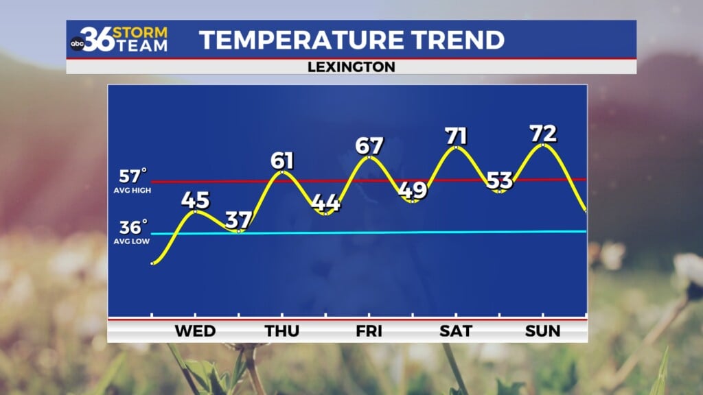
It was the same ole song and dance across Central and Eastern Kentucky on Thursday with plenty of clouds and unseasonably cold temperatures. In the wake of a departing frontal boundary, additional cold air drifted into the area so afternoon highs struggled to reach the freezing mark here in the Bluegrass with only mid-30s down south. Unfortunately we aren’t looking at any significant warm-up in the coming days so keep those winter coats handy.

A southern storm system along the Gulf Coast should throw enough moisture northward to squeeze out some light snow across Southern Kentucky into the early hours of Friday. The latest data has increased the wintry weather potential for our southern counties with accumulations looking more likely for that part of the commonwealth. As a result a Winter Weather Advisory is out until 7 am Friday for Southern Kentucky and until 10 am Friday for the mountains of Southeastern Kentucky. Those areas along and south of the Kentucky 80/Hal Rogers Parkway corridor look to have some negative travel impacts overnight and for the morning commute early Friday so plan ahead and be careful on the roadways. While much of it will fall in the form of snow, there could be a bit of a wintry mix also considering temperatures will be right around the freezing mark. Farther north here in the Bluegrass it looks dry and colder with readings into the low 20s early Friday. After daybreak the activity in the southeast should begin to wind down with much of the area should seeing mainly cloudy skies during the daylight hours as this system exits off to the southeast as afternoon highs remain chilly into the mid to upper 30s with a few low 40s down south.


The upcoming weekend looks quiet to start as weak high pressure to our south provides enough dry air for another day of scattered clouds with a little sunshine mixed in. Afternoon highs should climb back into the low 40s, which is better but still below average for this time in December. Another weak wave of energy will slide in from the west on Sunday with a few rain and snow showers possible depending on location and the temperature profile. Once again this doesn’t look like a very disruptive system and should be a quick in and out with improving weather heading into early next week.

It does appear that another reinforcing shot of chilly air will follow the departing wave on Monday so even with some sunshine expected (although we know the pattern of stubborn low clouds winning out and keeping the sunshine away this time of the year) afternoon highs will back off into the low to mid-30s so more chilly air will be on the table. Quiet conditions are expected Tuesday as winds pick up a bit with another fast moving system approaching from the northwest so a southwest breeze should push temperatures back into the 40s. The aforementioned system may bring more legitimate rain chances along with breezy and milder conditions mid-week with highs back closer to average before additional cold air follows suit.

ABC 36 Storm Team 36-Hour Forecast:
Thursday Night: Cloudy and cold, light snow/wintry mix south. Lows in the low-20s north and low-30s south. Wind: NE 5-10 mph.
Friday: Wintry weather ends southeast, then scattered clouds and chilly. Highs in the mid to upper-30s. Wind: SW 5 mph.
Friday Night: More clouds and cold temps. Lows in the mid to upper-20s. Wind: SW 5 mph.