Windy and mild to wrap up February
Temperatures should warm back up briefly before more cool air returns
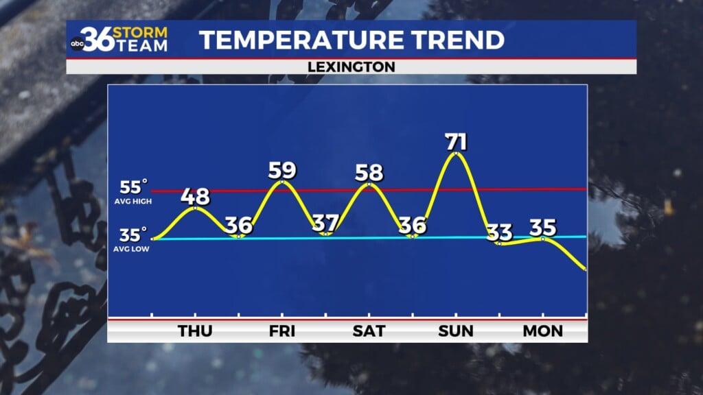
After a stretch of spring-like warmth earlier this week, today brought us back to reality with cooler temperatures and a brisk breeze. While the morning featured a few lingering showers, much of the day ended up dry aside from some scattered afternoon showers and even a few rumbles of thunder as an upper level wave scooted by to our northeast. Highs managed to climb into the mid to upper-50s but with a steady west wind gusting at times over 25 mph it certainly felt a bit cooler. That breeze sticks around tonight as we dip into the low 30s under mainly clear skies.

Winds Pick Up Friday with a Mild Finish to February
As we close out February on Friday, another weather system will be approaching from the northwest. Ahead of it our winds will shift back to the southwest and strengthen with gusts reaching 30-35 mph by the afternoon. While that breeze will be noticeable, it will also help boost temperatures into the upper 50s—several degrees above our seasonal average. We should see some sunshine breaking through at times making for a pleasant but windy end to the workweek.


March Arrives on a Cooler Note
A cold front will drop southward through Kentucky late Friday night, but this one won’t have much moisture to work with, so we’re not expecting any rain with it. What it will do is bring a sharp drop in temperatures to start the weekend. Saturday will be noticeably cooler with highs only reaching the low 40s and it should feel much colder than that with some wind chill factored in so keep that in mind as we kick off March. By Sunday morning we’re looking at lows in the upper teens and low 20s. That will be the coldest morning we’ve had in a while and a reminder that winter isn’t done with us just yet! Despite mostly sunny skies, highs Sunday will once again struggle to get out of the upper 30s and low 40s.


Looking ahead to next week, temperatures rebound quickly, with highs back near 50° by Monday. All eyes then turn to a more significant storm system by Tuesday and Wednesday, bringing widespread rain and possibly a few strong thunderstorms. There’s still some uncertainty on the exact timing and strength of that system with the favored area right now being across the Deep South for organized severe weather, but we’ll be watching closely for any potential severe weather risks in our area.

ABC 36 Storm Team 3-Day Forecast
Thursday Night: Clearing out, breezy and cold. Lows in the low-30s.
Friday: Mostly sunny, windy and milder. Highs in the low-60s.
Friday Night: A few clouds and chilly, still breezy. Lows in the upper 30s.
Be sure to check back for updates as we track next week’s storm potential! Stay with ABC 36 for the latest forecast.