Temperatures slowly rebound after the brief cool down
Afternoon highs will climb back into the 70s by late week
After record setting temperatures and a summer-like feel to close the weekend with afternoon highs urging into the mid to upper 80s across Central and Eastern Kentucky, we had a quick reality check on Monday as much cooler air returned to the Ohio Valley. With a brisk northwest wind pushing the cool air in along with some lingering clouds behind the departing cold front, temperatures started the day in the low-40s in most locations so you definitely needed the jacket early. We did manage to get back into some sunshine as the day wore on, which pushed afternoon highs back into the low-50s.

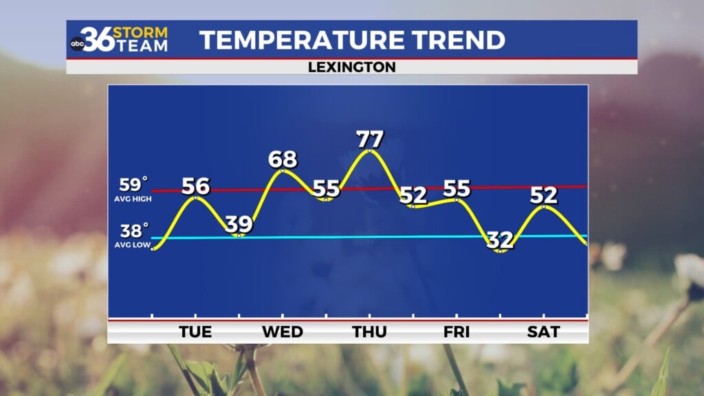
Expect a cold start to Tuesday with temperatures in the low to mid-30s out the door, a quick reminder that it is still early spring before we enjoy a pleasant late March day. High pressure will be sitting to our northeast so expect a mix of clouds and sunshine along with a steady east breeze. Afternoon highs should recover a few degrees into the mid-50s but we’ll stay a little below our average high temperature for late March as an east wind generally holds our temperatures down slightly as the cooler air-mass stays in place.


Heading into the midweek our quiet and tranquil weather pattern will stay in place as the aforementioned area of high pressure drifts off to the east. This will allow a return flow on the backside of the high so look for winds to shift around to the south. Combine this with more sunshine expected and afternoon highs should rebound quickly, jumping all the way back into the upper 60s to around 70 degrees, especially down south. A weak wave of energy should slide through the region on Thursday so a low end shower chance is possible but most locations should be dry. The strong southwest flow ahead of a cold front dropping in through the Ohio Valley will give us another surge of warmer air as afternoon highs roll all the way back into the upper 70s!

Scattered showers and storm chances look to increase Thursday night and into Friday as the cold front moves through so it looks to be a wet and cooler finish to the week. Depending on the timing of the front, temperatures may not recover much on Friday with “highs” in the 50s and it’s possible that temperatures could be dropping off through the afternoon as cooler air returns to the commonwealth. Another area of high pressure will settle in for the upcoming weekend and while we are looking at a return of sunshine across the region, we will see another round of cooler air with afternoon highs backing down into the low-50s on Saturday. The good news is that we should see a little recovery in temperatures with highs back around the 60 degree mark on Sunday with the upward trend continuing into early next week.

ABC 36 Storm Team 3 Day Forecast
Monday night: A few clouds and cold. Lows in the low-30s. Wind: NE 5-10 mph.
Tuesday: Partly sunny and pleasant. Highs in the mid-50s. Wind: E 5-10 mph.
Tuesday night: Scattered clouds, still chilly. Lows in the upper-30s and low-40s. Wind: E 5 mph.