Temperatures on the rise as we close out the winter season
A few showers will be possible heading into Thursday
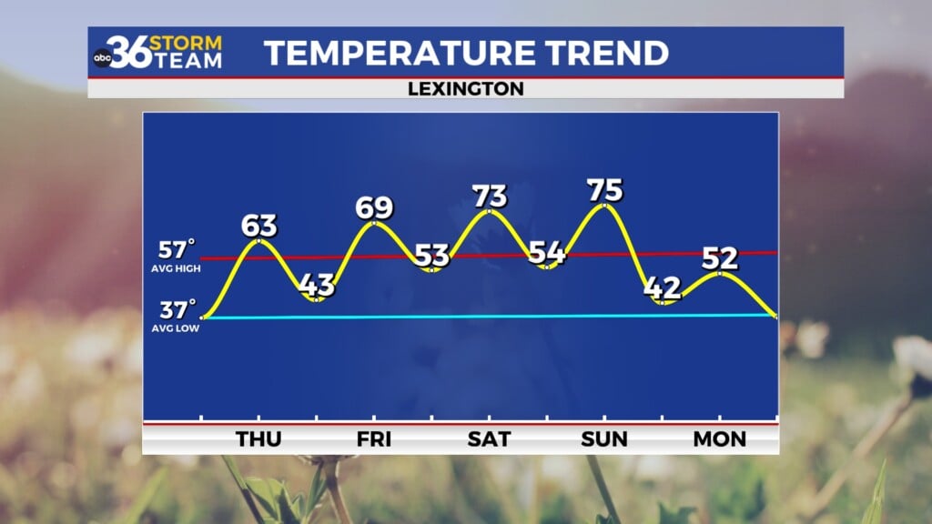
The unseasonably cold air in place that allowed multiple rounds of snow showers to Central and Eastern Kentucky the last couple of days started to relax a bit on Wednesday. It was a chilly start to the day with temperatures in the upper 20s at daybreak as the first of 2 clipper systems dropped through the Ohio Valley. With enough dry air at the surface, a lot of the moisture evaporated before reaching the ground and all we managed to squeeze out was a few sprinkles in isolated spots as temperatures started to rise through the day. A south wind helped push afternoon highs back into the mid to upper-40s and that upward trend will continue into the late week.

Another fast moving wave of energy will slide into the region from the northwest on Thursday keeping clouds and a low end chance of rain showers in play for Central and Eastern Kentucky. Much of the data isn’t really showing much in the way of rain showers so we may end up with yet anther dry day. After starting the day with temperatures in the mid to upper 30s, the south breeze will continue to push milder air our way so afternoon highs should make a run back into the low-60s, which is a bit above average for this time of the year.


Spring officially arrives at 10:46am Eastern time on Friday and Mother Nature should cooperate nicely with a milder day on the way. A wave of energy passing by to our east may provide some scattered clouds but overall the day looks dry with temperatures surging all the way either side of the 70 degree mark so it looks to be a good start to the season. The aforementioned wave may have enough moisture with it to squeeze out a few showers Friday night while folks are sleeping so keep that in mind. Heading into the weekend, spring-like conditions will continue across the area so it looks really nice for any outdoor plans you may have. Some early clouds should give way to afternoon sunshine as afternoon highs reach the low-70s across the board, Some of the data is pushing a mid-level wave through the Tennessee Valley with a few showers just to our south but we should be in good shaper overall with remaining dry.


The second half of the weekend looks good as well as a southwest wind ahead of a cold front dropping through the Ohio Valley keeps our weather quite pleasant on Sunday. Look for more sunshine with a few high clouds increasing late in the day ahead of the front but it shouldn’t take away from what will be another delightful day as afternoon highs reach the mid-70s, a good 15 degrees above average for late March. Our rain chances will pick up Sunday night and into Monday with the cold front moving in and a few rumbles of thunder can’t be ruled out. Cooler air will filter in behind the boundary with highs backing down into the low to mid-50s on Monday but that’s not drastically colder by any means compared to the winter chill we’ve been dealing with the last few days. Temperatures should rebound nicely by the mid-week with highs back in the 60s along with a low end shower chances thanks to some mid-level energy rotating through.

ABC 36 Storm Team 3 Day Forecast
Wednesday night: More clouds, not as cold. Lows in the mid to upper-30s. Wind: S 5-10 mph.
Thursday: Mostly cloudy and milder, a passing shower possible. Highs in the low-60s. Wind: S 5-10 mph.
Thursday night: A few clouds and cool. Lows in the low-40s. Wind: SE 5 mph.