Summer-like warmth set to continue this week
We'll see a few scattered showers and storms on occasion as well
After a sneak peek of the summer season to close out the weekend with afternoon highs in the low-80s, the unseasonably warm air stuck around Central and Eastern Kentucky to begin the week. A mid-level wave of energy scooting through the Ohio Valley brought cloudiness and a few scattered showers to the area with some folks seeing steady but beneficial rainfall, especially here in the Bluegrass where things were quite damp from late morning into the early afternoon hours. The rain really cooled things down for those areas that received rain for a period of time. However the steady southwest breeze continued to feed warm air in the commonwealth so afternoon highs still managed to reach the upper 70s in most locations despite the pretty extensive cloud cover across the region.

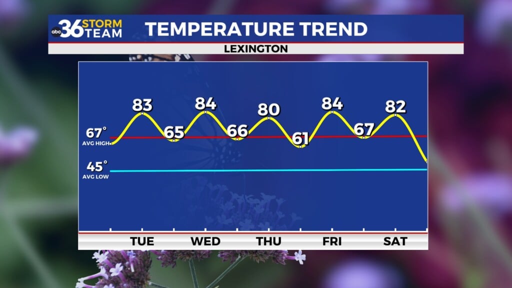
Heading into Tuesday, we’ll continue to sit on the western edge of a big ridge of high pressure along the east coast as a stalled out frontal boundary keeps active weather just to our west and northwest. This will keep things very summer-like with a little more sunshine around so afternoon highs will return back to the low-80s. There is the potential of seeing a few isolated storms fire up with the afternoon warmth but those should be few and far between. Overall it should be another good day to be outdoors, especially for the middle part of April.


More summer-like warmth is on the way for the mid-week as the ridge of high pressure to the east holds strong with the combination of more sunshine and a southwest breeze helping to push afternoon highs into the low to mid-80s. These numbers would put us very close to record territory on Wednesday with a mainly dry day expected. A wave of low pressure riding along the stalled out front to our northwest should get close enough on Thursday to bring a better chance of scattered showers and storms to the region. A few of the storms could potentially be on the strong side but the widespread severe threat looks to be fairly low. Temperatures will be held in check a bit by the clouds and scattered storms but highs will remain well above average with most spots topping out in the upper 70s.


We should be set-up for a nice finish to the week on Friday as we stay under the influence of the high pressure ridge to the east. This will bring another mainly dry day with sunshine and summer warmth as afternoon highs climb back into the low to mid-80s. Another frontal system will make a run for the Ohio Valley heading into the weekend so another round of showers and storms will be on the table as we kick off the weekend. You may have to adjust outdoor plans potentially given the storm threat but hopefully it won’t be a total wash-out. We’ll squeeze in one more unseasonably warm day with afternoon highs right around the 80 degree mark. Once the front moves through the region, cooler air will follow suit to close out the weekend Sunday with afternoon highs backing down into the low to mid-60s, which is much closer to average for this time of the year. Look for another stretch of quiet weather into early next week as temperatures recover into upper 60s to around 70 degrees for afternoon highs.

ABC 36 Storm Team 3 Day Forecast
Monday night: A few clouds, breezy and mild. Lows in the low to mid-60s. Wind: SW 10-15 mph.
Tuesday: Breezy and warm, a stray storm possible. Highs in the low-80s. Wind: SW 10-15 mph.
Tuesday night: Partly cloudy, still mild. Lows in the mid-60s. Wind: SW 10-15 mph.