Storms give way to cooler air into the late week
Afternoon highs may not get out of the 40s Thursday afternoon
It was a breezy and spring-like Thursday across Central and Eastern Kentucky as a cold front pressed into the area from the west. We started the day with lots of wind and a few storms to our north and west. The strong southwest breeze continued through the day with sustained winds around 20 to 30 miles per hour with some gusts reported over 50 miles per hour, including a 56 mph gust at Bluegrass Airport here in Lexington just Noon! The wind and mainly dry conditions helped push afternoon highs well into the upper 70s and we actually tied the record of 78 degrees here in Lexington for Wednesday’s date set back in 1990. With the front moving eastward, scattered storms fired through the afternoon. Some of those on the strong to severe side with damaging winds being the primary threat along with the typical low end tornado chance. With the front moving east of the commonwealth into the overnight hours, the storm threat should wind down as we see a brief shift in our weather pattern.

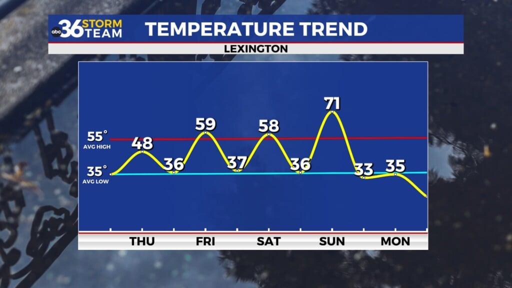
You’ll definitely feel the difference heading out the door early Thursday as much cooler air filters into the Ohio Valley in the wake of the departing cold front. Temperatures should be in the mid-30s early so you’ll need the heavier jackets once again. Clouds should linger for a while before we break out into some sunshine later in the day (although the cloud deck can be notoriously slow to depart) which should allow afternoon highs to recover into the upper 40s. This is a few degrees below average for this time in March and definitely a step back from the consistent spring-like air we’ve seen lately so be prepared for a cooler day.

A weak frontal boundary will approach from the northwest on Friday and once again we’ll see a good bit of wind ahead of this system. Look for winds gusting out of the southwest between 30 to 40 miles per hour as we see a mix of clouds and sunshine through the day. Given the lack of moisture with this front, we should remain rain free as afternoon highs recover back into the upper 50s to around 60 degrees. While this is an improvement over Thursday’s expected temperatures, the breezy conditions we’ll definitely make it feel a bit cool at times so keep that in mind. The frontal boundary should drop to our south heading into the weekend so we should be set up for a pretty decent Saturday, especially if you have outdoor plans. Temperatures should be even or maybe a few degrees cooler compared to Friday being on the northside of the front so expect afternoon highs in the upper 50s once again.


An area of low pressure will be on the move Sunday, so our rain and storm chances will pick up yet again. The boundary to our south should work back to the north as a warm front as the wave of low pressure and a cold front advance eastward. This should push afternoon highs back into the upper 60s as a breezy southwest wind kicks in. The first part of the day should be dry but as we get deeper in the day and more toward sunset, the chances for rain and storms will pick up. We’ll have to watch for the strong to severe storm potential as well given the dynamics with this system. A more significant shift in our weather pattern is on tap for early next week as we see a reality check and a reminder that winter isn’t officially over just yet. Temperatures will tumble behind the front with low to mid-30s expected by Monday morning along with a few scattered snow showers as the colder air catches up to the moisture. Expect little to no recovery for afternoon highs as we hang into the mid-30s so it will definitely be a big change from the recent spring-like pattern. Temperatures will stay unseasonably chilly into the middle of next week with a fast moving clipper system bringing some additional rain and/or snow showers to the Ohio Valley.

ABC 36 Storm Team 3 Day Forecast
Wednesday night: Breezy and much colder, lingering showers. Lows in the mid-30s. Wind: NW 10-15 mph.
Thursday: Morning clouds then slow clearing. Highs in the mid to upper-40s. Wind: NW 10-15 mph.
Thursday night: A few clouds and chilly. Lows in the mid-30s. Wind: W 5 mph.