Storm chances return Thursday as the warmth continues
The summer-like pattern will stick around the rest of the week
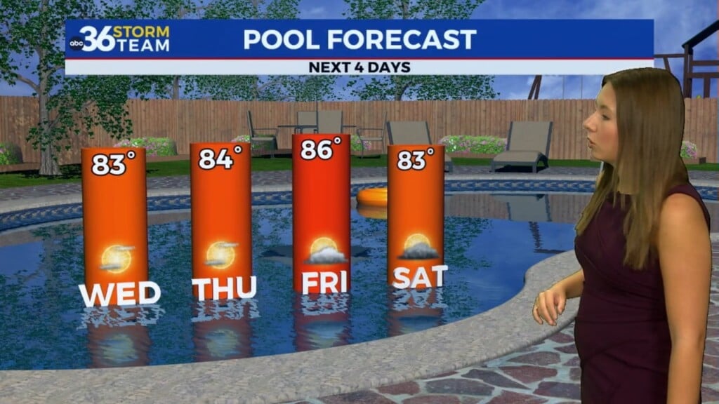
Our incredible stretch of summer-like warmth continued across Central and Eastern Kentucky Wednesday with another day of temperatures well above average for the middle part of April. The combination of sunshine, scattered clouds, and breezy southwest winds helped push afternoon highs into the low to mid-80s across the board. Temperatures were warm enough to flirt with record high territory yet again and this made for ideal conditions to be outdoors, so hopefully you had a chance to soak up the warm air.

The quiet and dry weather will be interrupted a bit on Thursday as a wave of energy slides through the Ohio Valley. This will increase the chances for a few scattered showers and thunderstorms around the region, which isn’t a bad thing given the overall dry conditions/drought situation that is on-going. There is the potential that a few of the storms could be on the strong side with damaging winds and possibly some hail on the table. The Storm Prediction Center has most of Central and Eastern Kentucky in a Level 1 severe weather risk (out of 5) for that potential although this doesn’t appear to be an overly concerning threat. Temperatures will be held in check a bit but still unseasonably warm with afternoon highs in the upper 70s.


We’ll close out the week in style with another sneak preview of the summer season on Friday as sunshine returns along with the warm temperatures. Afternoon highs should work back into the low-80s so it should be another banner day by mid-April standards. A change in our overall weather pattern will begin to kick on as we head into the weekend thanks to a cold front moving in from the west. Look for more showers and storms to return to the commonwealth, especially as we get deeper into Saturday so keep that in mind for any outdoor plans you may have this weekend. Once again there could be a few strong storms in the mix and that’s something we’ll keep an eye on as we get closer to that time frame. We’ll squeeze in one more day of summer-like temperatures with afternoon highs into the upper 70s before some changes kick off.


Look for a reality check the second half of the weekend and into early next week as cooler air makes a return appearance to Central and Eastern Kentucky behind the departing cold front. After a few showers in the morning it should begin to dry out but the most notable change will be about a 20 degree drop in temperatures compared to the summer pattern we’ve enjoyed lately. Afternoon highs will struggle to get into the low-60s Sunday and while this is just a few degrees below average for mid-April, it is quite a change from the persistent warmth of late. Next week will start chilly on Monday morning with temperatures in the 30s at daybreak as cool high pressure keeps us into the low to mid-60s for afternoon highs despite plenty of sunshine. Fortunately we’ll see a nice warm-up kick in toward the middle of next week with mainly dry conditions, although a few shower chances could return toward next Wednesday.


ABC 36 Storm Team 3 Day Forecast
Wednesday night: Scattered clouds, breezy and mild. Lows in the mid-60s. Wind: SW 10-15 mph.
Thursday: Mostly cloudy, a few storms possible. Highs in the upper-70s. Wind: SW 10-15 mph.
Thursday night: Partly cloudy, lingering showers. Lows in the upper-50s to around 60 degrees. Wind: SW 5-10 mph.