Sneak preview of winter gives way to a milder days ahead
Highs will be back in the 60s by the end of the week
We saw an early taste of the winter season across Central and Eastern Kentucky to begin the week on Monday with snow showers and squalls around the area thanks to an upper level system overhead and cold enough air to support frozen precipitation. This activity was scattered but localized areas saw heavier snow bursts and enough for some light accumulations and low end impacts. This was basically the equivalent of the convective, “pop-up” storms we see during the summer months with the activity being pretty scattered, yet intense in some spots. It was definitely a cold day even for early November with highs struggling into the low to mid-30s and breezy conditions putting our wind chills down into the low 20s.

The upper level system will shift eastward as another weak wave of energy rotates in from the west Tuesday, helping to scour out the early shot of winter cold. It does look unseasonably cool on Veterans Day though with a mix of clouds and sunshine along with afternoon highs creeping back into the low to mid-40s, which is well below average for the early to middle part of November. Make sure and bundle up in the morning as temperatures will drop into the low 20s and with a bit of a breeze still in place, those “feel-like” temps will be well into the teens to kick off the day.


Heading into the midweek more tranquil weather is expected across the region even with a weak boundary sliding through followed by a quick shot of high pressure. Look for mostly sunny skies and a breezy southwest wind on Wednesday, which will push afternoon highs all the way back into the upper 50s. This will feel very nice considering the colder air of the early week so it should be comfortable to be out and about. Temperatures will back down a few degrees with mid-50s on tap for Thursday as high pressure settles in behind the departing front so more nice fall weather will continue into the late week.

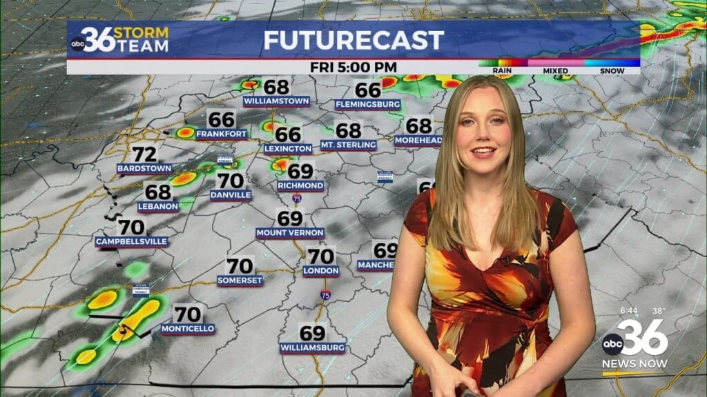
A mid-level wave of energy sliding through the commonwealth may produce a few clouds and a passing shower on Friday as we close out the week but overall most spots should be dry. Temperatures should continue to climb with afternoon highs into the low to mid-60s. The weekend looks good to start with more sunshine and pleasant conditions on the docket along with even milder air. Highs look to climb back into the mid to upper 60s, so it will be good to have above average temperatures back in play for any outdoor activities. Kentucky caps off their 2025 home football schedule against Tennessee Tech on Saturday at 1:30 PM at Kroger Field and the weather should cooperate nicely for the game. The data is showing a more significant system arriving Sunday and into early next week so our rain chances will ramp up then. We’ll have to watch for the strong to severe storm potential as well as some of the parameters may be in place for that so we’ll monitor that aspect of it in the coming days.


ABC 36 Storm Team 36-Hour Forecast:
Monday Night: Clearing out, breezy and cold. Lows in the low-20s. Wind: W 10-15 mph.
Tuesday: Partly sunny, still chilly. Highs in the low-40s. Wind: SW 10-15 mph.
Tuesday Night: Mostly clear and quiet. Lows in the mid-30s. Wind: S 5-10 mph.