Rain chances return for the late week
Severe weather isn't expected but some locally heavy downpours are possible
Wednesday brought more gorgeous spring weather across Central and Eastern Kentucky. With sunshine dominating for much of the day and highs soaring into the mid and upper 70s, it was perfect for spending time outdoors. A weak front stalled to our south managed to drift just far enough north to stir up a few isolated showers and storms in southern Kentucky during the late afternoon hours, but most of us stayed dry from start to finish.

Rain Gear Returns for the End of the Week
The calm and mild trend won’t last much longer. As we head into Thursday, that same frontal boundary will lift northward as a warm front, tapping into moisture streaming up from the Gulf. This will lead to scattered showers and a few thunderstorms, especially during the afternoon. Not everyone will get wet, but don’t be surprised if you hear a rumble of thunder or two. Despite the rain chances, highs will still reach into the upper 70s, making it feel more like late spring.

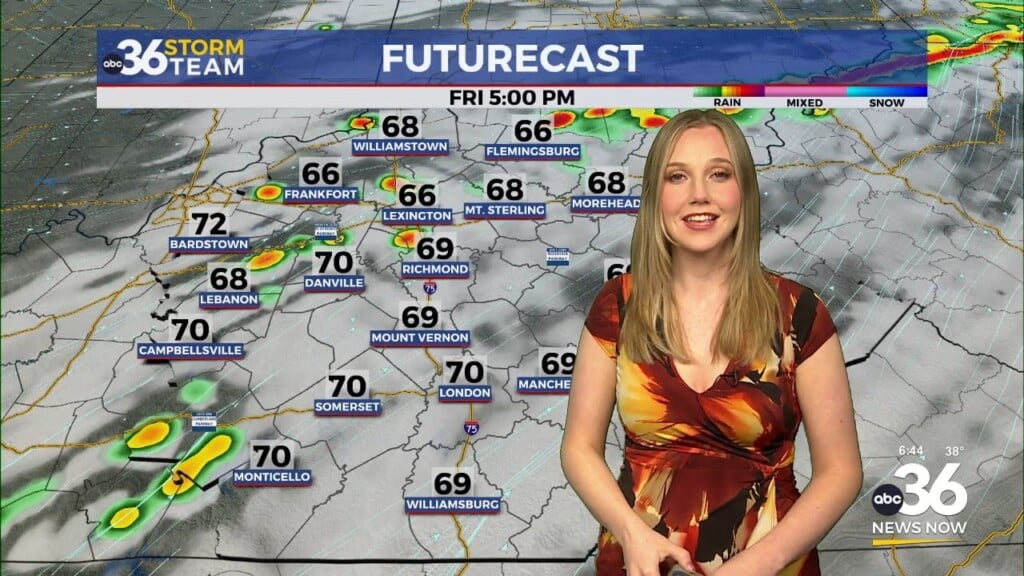
Soaking Setup for Friday
Friday brings our best shot at widespread rain and storms as an area of low pressure rides into the Ohio Valley and drags a cold front through the region. With deep moisture in place and multiple rounds of rainfall possible, locally heavy downpours could become an issue—especially Friday afternoon into Friday night. Severe storms aren’t expected, but some spots could pick up around an inch of rain when all is said and done. The threat for flooding remains low, but some ponding on roads and minor stream rises are possible where heavier rain sets up.


Drying Out for the Weekend
That cold front looks to clear the region by early Saturday, bringing an end to the rain from west to east through the day. Clouds may hang around early on, but by afternoon we’ll start to see some clearing skies with highs topping out in the low 70s. Sunday’s shaping up to be the pick of the weekend—mostly sunny, dry, and seasonably mild with more highs in the low 70s.

A Touch of Summer Next Week
Looking ahead, warmer air will return for the final week of April. By Monday and Tuesday, highs will climb into the low and even mid-80s in spots. It’ll feel much more summer-like, and with the heat, we could see a few pop-up showers or storms each afternoon. A stronger system may arrive midweek, bringing another shot at more widespread rain and storms.

Wednesday Night: A few clouds and pleasant. Lows in the upper-50s. Wind: SE 5 mph.
Thursday: Mostly sunny with a few scattered afternoon storms. Highs in the upper-70s. Wind: S 5-10 mph.
Thursday Night: Mild with a few isolated storms. Lows in the low-60s. Wind: S 5-10 mph.