Pleasant mid February weather to close out the week
Afternoon highs will climb back into the 50s by Valentine's Day
After a chilly start to the day with temperatures in the mid-20s which created a few spots of black ice for the morning commute due to the recent snow/ice melt, it was a pleasant February day on Thursday across Central and Eastern Kentucky. With high pressure dominating at the surface, we saw some filtered sunshine as a few scattered clouds drifted through the area. Afternoon highs managed to work back into the low to mid-40s, which is right around average for this time of the year and fortunately we’ll see even milder readings heading into the weekend.
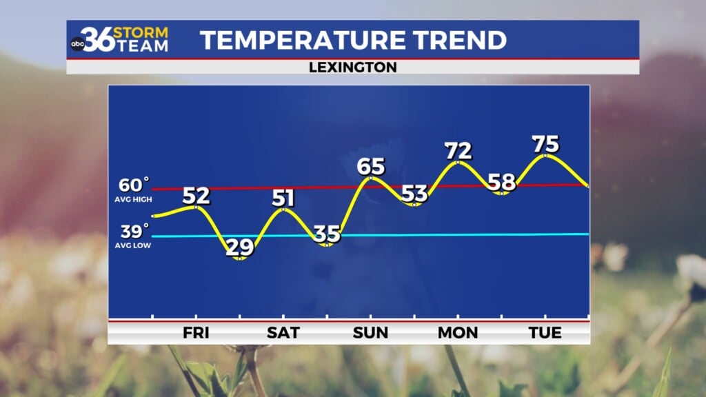
Expect a quiet Friday across the region as the area of high pressure drifts off to our southeast. You’ll want to use caution again for the morning commute as temperatures drop back into the mid to upper 20s for morning lows, which would create some additional black ice concerns given any moisture on the roadways from leftover snow and ice melting off. With plenty of sunshine around, afternoon highs will climb back into the upper 40s with a few low 50s possible down south. This will make for a very nice finish to the week, especially considering the lengthy stretch of Arctic cold we dealt with through the end of January and into early February.
Valentine’s Day looks pretty sweet overall with mainly dry and pleasant conditions expected across the commonwealth, even as our next storm system cranks up to our southwest. After some sunshine early, clouds will slowly increase through the day but we’ll still see afternoon highs surge into the mid to upper 50s. This will be ideal for any Valentine’s Day plans, although you may want to take an umbrella along if you have dinner plans in areas west of the I-75 corridor as a few showers may sneak up before Midnight. The bulk of the rain is expected to fall Saturday night and into Sunday as a wave of low pressure slides by to our south. Rainfall should be solid, with a good 0.50″ to 1″ possible across the board with Southern Kentucky expected to see a few spots with possibly over an inch. Given the saturated ground from the recent snow/ice melting off, a few minor flooding issues may be realized so keep that in mind.
Fortunately we won’t see a big push of chilly air behind the departing system into Presidents Day on Monday. In fact, high pressure should bring milder air along with it so look for temperatures to climb all the way into the upper 50s for the holiday. Another sneak preview of spring may be on the way into the middle part of next week as a southwest flow cranks up, pushing unseasonably mild air back into the Bluegrass. Afternoon highs are expected to surge into the low to mid-60s, which will feel fantastic for this time of the year. A frontal boundary will approach from the west late Wednesday and into Thursday so a few rain showers will return to the area during that window.
ABC 36 Storm Team 3 Day Forecast
Thursday night: Fair skies and cold. Lows in the mid to upper-20s. Wind: E 5 mph.
Friday: Mostly sunny and pleasant. Highs in the upper-40s. Wind: SE 5 mph.
Friday night: Mostly clear, cold again. Lows in the low-30s. Wind: SE 5 mph.


