More beneficial rain on tap into the mid-week
Look for an additional 1" to 2" possible through Thursday
It was just what the doctor ordered to begin the week Monday as multiple rounds of showers and thunderstorms moved across central and Eastern Kentucky bringing a healthy dose of much needed rainfall to the area. Most locations picked up a solid 1″ to 1.5″ of rain as a mid-level wave pushed through the region. We did have a bit of severe weather with a few wind damage reports but fortunately it was nothing widespread. Tuesday brought a brief break in the action with just a few isolated storms as we were in between systems so it was dry for most as afternoon highs reached the low-80s.

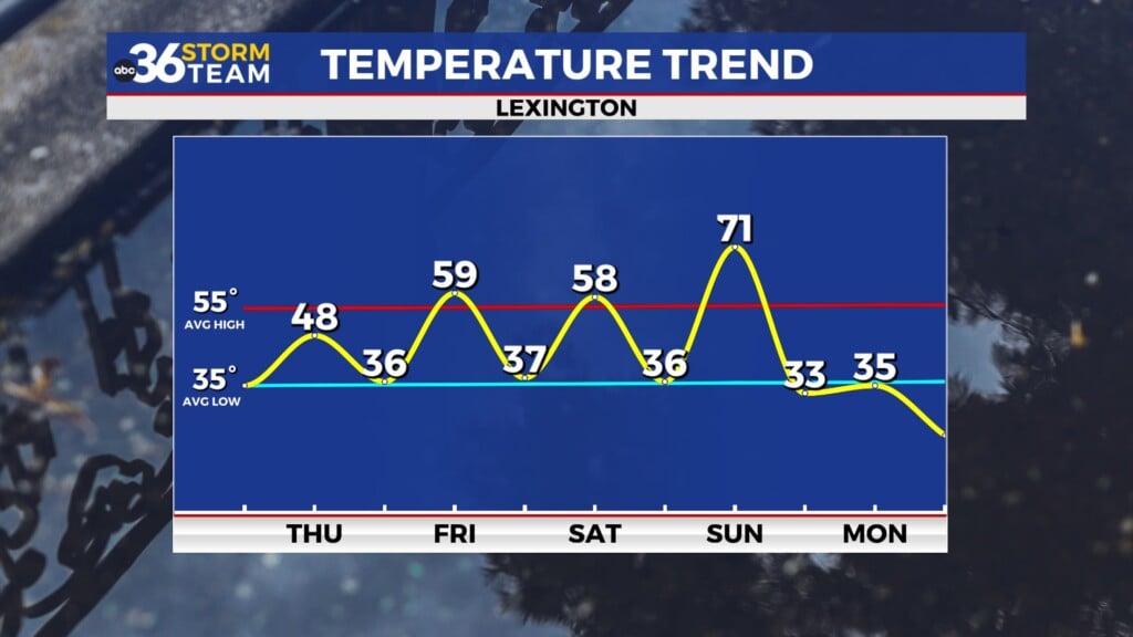
Heading into Wednesday another area of low pressure and a trailing cold front will make a run for the Ohio Valley bringing another legitimate chance of widespread showers and thunderstorms to the commonwealth. Much of the data indicates we could see additional rainfall totals in the 1″ to 2″ range, which would go a long way to alleviating the drought conditions here in Central Kentucky. Once again we are looking at a low end severe weather threat as the Storm Prediction Center has all of Kentucky in a Level 1 severe weather risk (out of 5) with damaging winds being the primary threat. There is the chance we could see that bumped up to a Level 2 so just be weather aware given how quiet our overall pattern has been the last month or so. Afternoon highs will be held in check due to the expected clouds and rain with highs in the upper 70s.


The late week should feature the frontal boundary slowly working its way out of the state thus bringing an end to our wet weather pattern during these first few days of fall. Scattered showers and storms will be possible mainly during the first half of Thursday as the front presses eastward so look for more wet and stormy conditions, especially during the morning hours. We should dry out from west to east through the course of the day as afternoon highs remain in the upper 70s for most spots. By Friday we should be looking at a mainly dry day with the only X factor being some upper level energy cut off to our southeast, which could throw some moisture back into Eastern Kentucky but the chances of this are pretty low. We should be set-up for another good night for high school football games across the area with comfortably warm temperatures.

Look for another dry and tranquil pattern to settle in this weekend with typical early fall conditions on tap across the region. It should be a very nice final weekend of September with mostly sunny skies and afternoon highs either side of the 80 degree mark depending on location. The fall festival season is in full swing with a long list of events going around around the commonwealth. At this point high pressure looks to win out nicely keeping things high and dry so it should be a delightful stretch of weather through the weekend and early next week as temperatures gradually warm back into the low-80s for highs as the sunshine stays in place.

ABC 36 Storm Team 36-Hour Forecast:
Tuesday Night: Mostly cloudy, storm return late. Lows in the mid-60s. Wind: S 5 mph.
Wednesday: Scattered rain and storms. Highs in the upper-70s. Wind: S 5-10 mph.
Wednesday Night: Rain and storms continue. Lows in the low-60s. Wind: S 5-10 mph.