Milder air returns briefly to kick off the weekend
A more February like weather pattern will settle in next week
It was a quieter and cooler finish to the week across Central and Eastern Kentucky after Thursday’s active and stormy weather. Southern and Southeastern Kentucky were hit hardest, with multiple Tornado Warnings and reports of wind damage. The cold front responsible for the severe storms pushed eastward, allowing for a return of sunshine and cooler temperatures in the upper 40s on Friday. However, the active pattern we’ve seen this week is not over just yet, with another round of milder air arriving before temperatures settle back to more February-like levels.

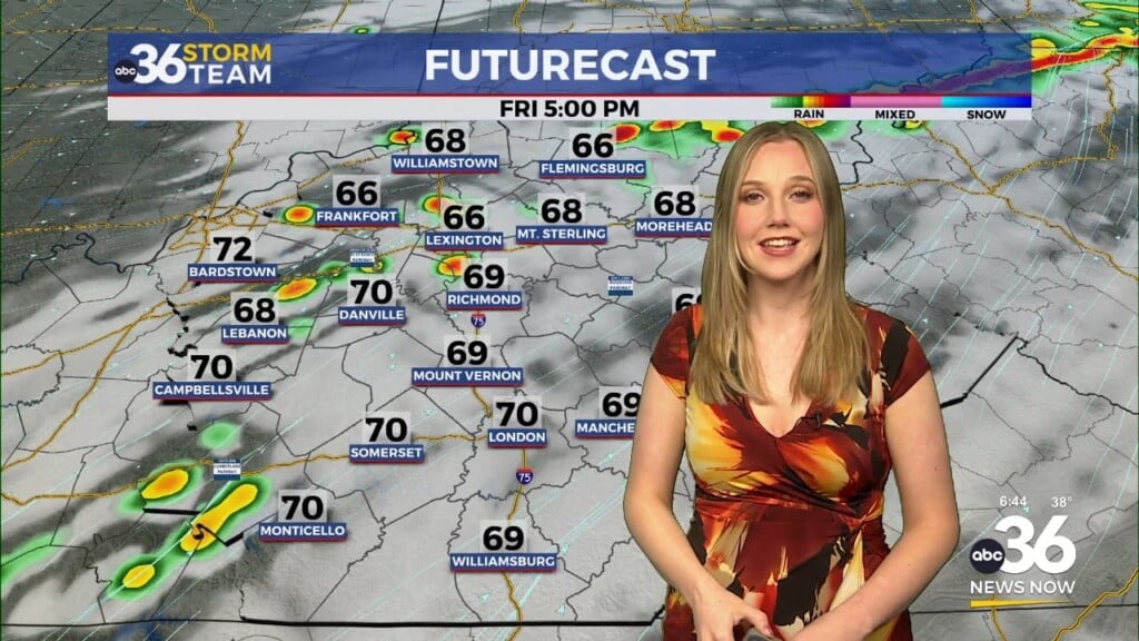
Weekend Outlook: Another Warm-Up Before a Cool Down
Saturday will bring another warm front lifting northward into the state, bringing an increase in rain chances overnight into the early morning hours. Temperatures will gradually climb from the upper 30s into the low to mid-40s by sunrise as scattered showers develop. As a wave of low pressure moves toward the Great Lakes, the warm front should advance just north of the I-64 corridor, pushing afternoon highs into the low to mid-60s. A strong southerly wind will accompany this system, and while a few rumbles of thunder are possible, severe storms are not expected this time.

By Sunday, colder air will settle back into the region behind the departing cold front. Most of the rain will clear out early, allowing for a mix of clouds and sunshine to end the weekend. Highs will struggle to reach the low 40s, with a steady north breeze making it feel even cooler. Monday remains mostly dry, but cloud cover will linger as the weekend’s frontal boundary stalls just to our south. Afternoon highs will stay seasonably chilly in the lower 40s.

Early Next Week: Watching for Wintry Weather
Attention then turns to Tuesday, when a system sliding to our south could bring the first of two potential waves of wintry weather. The exact track of this low-pressure system will determine whether we see rain, snow, or a mix. Right now, the northern half of Kentucky appears to have the best chance for accumulating snowfall, while locations farther south may see more of a cold rain. This will be one to monitor closely for potential travel impacts.

Another system is expected by Wednesday and Thursday, and with ample moisture available, this setup favors a mainly rain event. However, given the already saturated ground, flooding concerns will increase, especially along area rivers and streams.

ABC 36 Hour Forecast:
- Friday night: Rain returns with rising temperatures into the low 40s.
- Saturday: Breezy and milder with showers and storms, highs in the low 60s.
- Saturday night: Drying out and turning colder again, lows in the low 30s.
Stay with ABC 36 for updates as we track these changing conditions!