Less humidity and drier air works in to close out the week
A weak frontal boundary will drop to our south allowing for a more comfortable Friday with highs in the mid to upper 80s
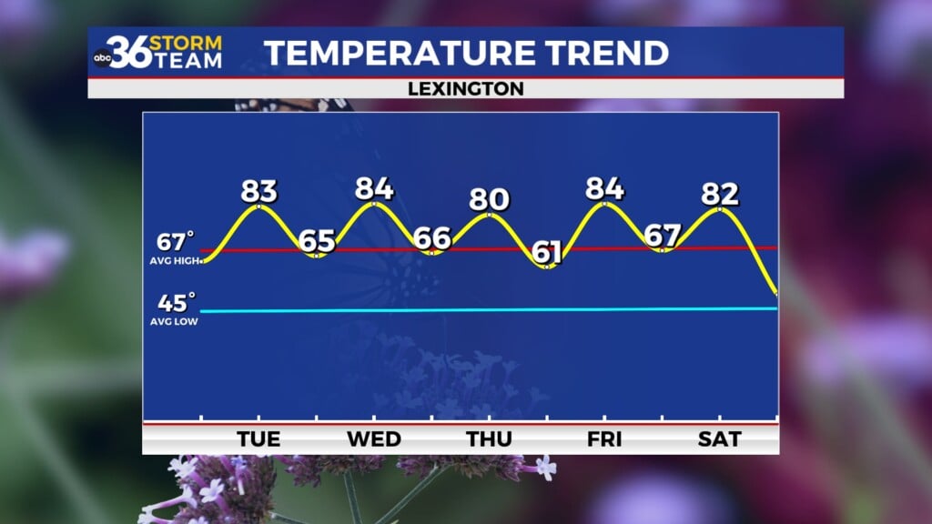
A weakening cold front dropped through the commonwealth with very little fanfare as the expected isolated storms through the afternoon were just that…very isolated. With a mix of clouds and sunshine temperatures managed to overperform in many locations thanks to the lack of organized rainfall. Most locations topped out into the mid to upper 80s and while it was still on the humid side across the area, that should change as we finish out the week.

High pressure sitting over the Great Lakes should set us up for a nice Friday across Central and Eastern Kentucky, especially by late July standards. With what is left of the front stalling out just to out south in a weakened state enough dry air on the heels of a light northeast wind should make it feel much more comfortable and we catch a brief break from the high humidity levels of late. With a good bit of sunshine around afternoon highs should reach the upper 80s in most spots, which is right on par for average this time of the year. Our far southern counties could still see a little bit more in the way of humidity as the commonwealth will be sitting just to the north of where the deeper moisture will be sitting on Friday so the farther south you go, the muggier it may feel.


Heading into the weekend we are still looking mainly dry across the area as high pressure hangs on for one more day as it slowly drifts to the east. The leftover boundary may try to drift northward but there shouldn’t be much left of it and not much of a trigger to get much activity going across Southern Kentucky, which would be the favored area for any stray storm. We will see our temperatures continue to climb with more sunshine so expect a hot one on Saturday with highs in the low 90s.
By Sunday the return flow off the Gulf of Mexico will be in full swing allowing plenty of moisture and humidity to make a return to the Ohio Valley. This will increase our chances for scattered showers and storms to end the weekend with our best chance of more widespread showers and storms coming on Monday and Tuesday. The “muggy-cast” really takes a jump into early next week and as we get the warmth/heat cranked up through the afternoon hours we should see some legitimate rain and storm chances, which is good news given the we are still unusually dry across the area.


Speaking of dry, the latest Drought Monitor is out today and we’ve only seen some slight changes in Southern Kentucky even with some localized heavier rain on several occasions over the last week. A small part of the Kentucky 80 corridor down the Hal Rogers Parkway in Southern Kentucky managed to get back to even but the rest of Eastern Kentucky is still in the “abnormally dry” category. The Bluegrass region and points south of Lexington are in the “Moderate Drought” so this remains basically unchanged from last week. The bottom line is we need some legitimate widespread rain chances and we could potentially see some into early next week.

ABC 36 HOUR FORECAST
THURSDAY NIGHT: Scattered clouds, not as muggy. Lows in the mid-60s.
FRIDAY: Mostly sunny and warm. Highs in the mid to upper-80s.
FRIDAY NIGHT: Mostly clear and quiet. Lows in the low-60s.