Fast moving clipper systems keep things unsettled as temperatures moderate
More light snow showers will be possible early Wednesday
Our not so subtle reminder from Mother Nature that the winter season is over yet continued on St. Patrick’s Day across Central and Eastern Kentucky as the unseasonably cold air stayed locked in. It was a rough morning in the Lexington area as a burst of snow showers covered the ground just prior to the morning commute creating slick roadways and leading to numerous accidents as a result with temperatures in the low 20s. Once the snow showers tapered off and some sunshine tried to break through, we still didn’t see much change with an unseasonably cold afternoon as temperatures struggled to get back into the low 30s.

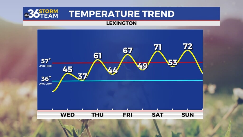
The first in a series of clipper systems will drop through the Ohio Valley heading into Wednesday bringing some additional snow shower chances to the commonwealth. It appears the most favorable area for light snow showers will be across the northern half of the state and it could once again arrive close to the morning commute. Temperatures should rise a bit overnight and are expected to be in the upper 20s by daybreak, you’ll need to check conditions in the morning given that the data varies in the arrival of the snow, although the majority of it may move in mid to late morning. A south breeze will push milder air in so temperatures may climb into the upper 30s pretty quickly with the snow showers changing to rain showers through the late morning before ending by early afternoon. Afternoon highs should recover into the mid-40s by the end of the day so it will feel much better than the last few days.


The “clipper train” looks to continue as we head into the final day of winter on Thursday as another wave of energy slides into the region from the northwest. The good news is that temperatures will be mild enough to where everything will be in the form of a few rain showers so we shouldn’t see any issues relative to snow and/or slick roads. The steady southwest wind will help push afternoon highs into the low-60s so it should feel much more like what we’ve become accustomed to much of March so far here in the commonwealth. Spring officially arrives at 10:46am Friday morning and the weather should cooperate nicely with partly sunny skies and afternoon highs urging back into the upper 60s so look for a good start to the news season.


Heading into the upcoming weekend our weather looks pretty late for late March with some sunshine expected and afternoon highs right around 70 degrees on Saturday. This will be pretty ideal for any outdoor plans you may have on your calendar and even if you don’t have any, try to get outside for a bit and enjoy the milder air of early spring. We should see a repeat performance on Sunday with low-70s for afternoon highs as we do begin to see a few clouds drift in from the north ahead of an approaching cold front. There is the potential of a few light showers heading into Sunday night as the front drifts through but most locations will be dry. The biggest change into early next week will be slightly cooler air behind the front with afternoon highs back down into the 50s for a few days, which is closer to average for this time of the year.

ABC 36 Storm Team 3 Day Forecast
Tuesday night: Mostly cloudy, steady/rising temperatures. Lows in the mid-20s early. Wind: S 5 mph.
Wednesday: A.M. snow/rain showers, milder late. Highs in the upper 40s. Wind: S 10-15 mph.
Wednesday night: More clouds, not as cold. Lows in the mid to upper-30s. Wind: S 5-10 mph.