Fantastic weather continues Friday ahead of some weekend changes
Rain chances return along with windy conditions by Saturday night
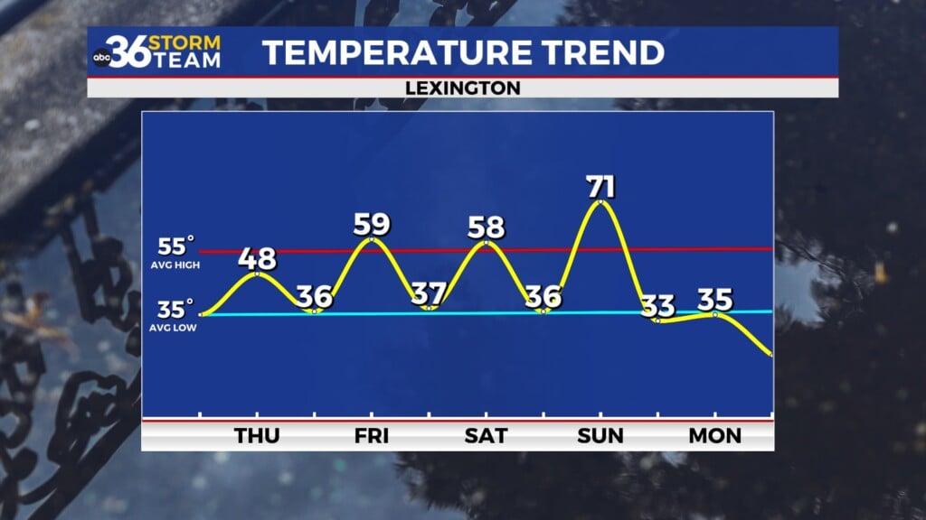
It was another banner day of weather Thursday across Central and Eastern Kentucky with lots of sunshine and very pleasant temperatures thanks to a strong area of high pressure sitting over the northern part of the Ohio Valley. So low to mid-level cloudiness acted as a blanket during the overnight hours, preventing temperatures from dropping so morning lows were in the 50s in most spots/ Despite the “milder” start, a steady northeast wind coming around the area of high pressure helped hold our temperatures down through the day as afternoon highs ended up right around average for this time of the year with the majority of locations topping out in the upper 60s to around 70 degrees.

Friday looks like a perfect finish to what has been a great week of weather with more sunshine as temperatures start to bounce back nicely. As the high drifts eastward, a return flow will begin to set-up, allowing afternoon highs to climb back into the low to mid-70s across the board. Once again it should be a very pleasant night for high school football around the commonwealth with unseasonably mild temperatures through the evening hours, especially for being this deep into the regular season with just a few weeks left before the playoffs kick in!


The tranquil weather pattern will come to an end over the upcoming weekend but not before squeezing in almost a late summer-like Saturday around the area. With a cold front approaching from the west, strong southwest winds coupled with some sunshine will push afternoon highs all the way into the low 80s across the region so it should feel fantastic across the area! It will be a bit on the breezy side with wind gusts in the 20 to 30 miles per hour range so keep that in mind as it’s been awhile since we’ve seen a day with strong winds around. That being said, it looks fabulous for tailgating leading up to the Kentucky/Texas game at Kroger Field on Saturday evening and the data continues to indicate the rain and storm chances will hold off (other than a stray shower chance) until after the game. Take the rain gear along just to be on the safe side but it should fee; amazing for a night game in mid to late October at Kroger Field with temperatures remaining in the 70s!


The bulk of the rain and storms will arrive Saturday night and into Sunday so look for a wet and stormy finish to the weekend. The timing of the activity should cut down on the overall strong to severe storm threat but some heavier rain will be possible at times. Rainfall totals still look to be around 1″ or so, which is always good to get that much rain this time of the year. As the front moves eastward and the rain winds down Sunday afternoon, the big story will be some strong wind gusts in the wake of the departing front. Look for winds to gust 30 to 40 miles per hour out of the west/northwest as cooler air pours into the commonwealth. You’ll definitely feel the difference outdoors as afternoon highs should only reach the mid to upper 60s.


Heading into next week look for a quick shot of high pressure with a mostly sunny and dry Monday as afternoon highs reach the upper 60s. Another fast moving system will dive into the area from the northwest by Tuesday so look for a low-end showers and storm chance as temperatures briefly climb back into the low-70s for highs. Once this system clears the area into the middle of next week, it will feel more like late October with temperatures dropping back into the mid-60s during the afternoon highs as we rapidly head toward the end of the month.
ABC 36 Storm Team 36-Hour Forecast:
Thursday Night: Mostly clear, a bit chilly. Lows in the mid-40s. Wind: E 5-10 mph.
Friday: Mostly sunny and milder! Highs in the low to mid-70s. Wind: SE 5-10 mph.
Friday Night: Mostly cloudy with a stray shower. Lows in the mid-50s. Wind: S 5-10 mph.