Delightful October weather stays in place this week
Some changes may be on the horizon by the upcoming weekend
After a great weekend of fall weather across Central and Eastern Kentucky for any outdoor activities thanks to sunshine and pleasant conditions, we saw more of the same to begin the week Monday. The Ohio Valley was in a perfect spot squeezed between a Nor’easter over New England and a weak front across the Central Plains so we enjoyed more sunshine and comfortable temperatures as afternoon highs reached the mid-70s across the board.

Look for more of the same into Tuesday as the tranquil weather pattern stays in place for the time being. After starting out the day pleasantly cool with temperatures in the upper 40s, temperatures should rebound nicely with afternoon highs back in the mid to even upper 70s, which is several degrees above average for the middle part of October. The departing system over New England should keep the persistent northeast wind in place, which will add to the comfort factor through the day as humidity levels remain very low.

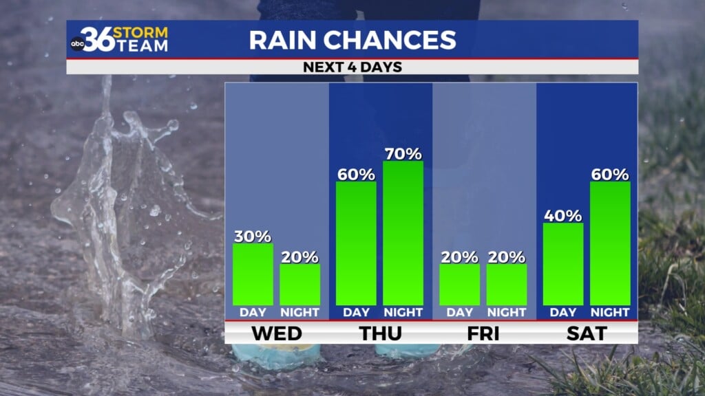
Heading into the mid-week, a dry frontal boundary will drop through the Ohio Valley ushering in a reinforcing shot of mild October for the commonwealth. Other than a few scattered clouds around, all we should see is a shift in wind direction back to the north/northwest which will knock temperatures back a few degrees across the area. Look for afternoon highs to back down toward the 70 degree mark with a few upper 60s sprinkled in. This will of course back morning lows down deeper into the 40s for a couple of days so those light jackets will come in handy early.

Temperatures should rebound nicely by Friday and the upcoming weekend as a southwest flow returns ahead of an approaching cold front. It looks like a nice finish to the week and yet another delightful Friday night for high school football as we hit the home stretch with just a few weeks of the regular season left. Saturday look breezy and warm for mid-October as high run back into the upper 70s as the aforementioned front looks to make a run through the Ohio Valley. The model data isn’t synced up with the timing yet but it appears the best chances for rain and storms will be Saturday night and into Sunday so we should be in good shape as Kentucky returns to Kroger Field for the first time in about a month to take on Texas on Saturday evening. We will have to watch the potential for a few strong storms will this system as it moves through but right now the better dynamics for organized severe weather will stay to our west and the timing of the front moving into the commonwealth may work to our advantage. Stay tuned!


ABC 36 Storm Team 36-Hour Forecast:
Monday Night: Clear skies and pleasant. Lows in the upper-40s. Wind: N 5-10 mph.
Tuesday: More sunshine, very nice! Highs in the mid to upper-70s. Wind: NE 5-10 mph.
Tuesday Night: Mostly clear and quiet. Lows in the upper-40s. Wind: NE 5-10 mph.