Cool and quiet weather on the way for the mid-week
Our first widespread frost looks to be on the horizon
With a weak cold front moving across the Ohio Valley on Tuesday we started the day with some cloud cover but the surface was dry enough to keep most locations rain-free. Once the sunshine returned through the afternoon, brisk west winds kicked in with gusts in the 20 to 30 miles per hour range so it was another breezy October day in the Bluegrass. Thanks to the sunshine, afternoon highs did manage to sneak back into the upper 60s which is right around average for this time of the year.

Quiet weather is expected into the mid-week despite an upper level low rotating through the Great Lakes, which will keep our winds up a bit through Wednesday. After starting out in the low-50s, afternoon highs should only reach the upper 50s to around 60 degrees despite a good bit of sunshine around thanks to the persistent and stout west breeze. Wind gusts again could be in the 20 to 30 miles per hour range so it may definitely feel even cooler than the actual air temperatures, even with some decent sunshine around so plan accordingly.

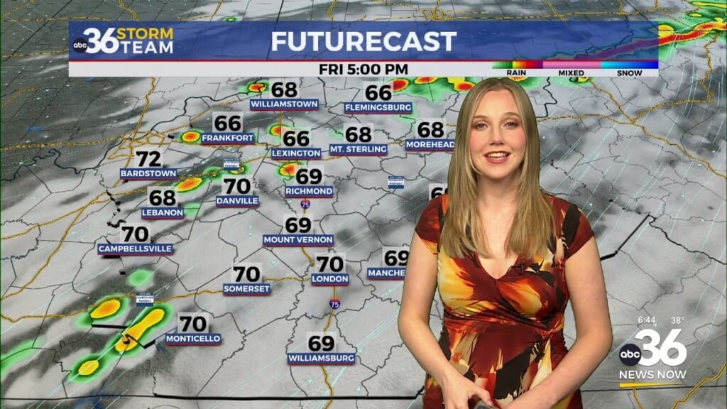
As the upper low pulls off to the northeast and high pressure settles in, the potential for a widespread frost across Central and Eastern Kentucky is increasing in the late week window. Early morning lows should dip down into mid to upper 30s on Thursday morning so some areas will see some patchy frost here and there. The rest of the day looks fantastic for late October with sunshine and highs back into the low 60s. The optimal set-up for widespread frost now looks to be on Friday morning with clear skies and light wind expected, which will allow temperatures to drop into the low to mid-30s. You’ll need to protect those tender plants if you want to hang onto them a while longer and a Frost Advisory may be needed during that time. High clouds will build in to close out the week Friday with some filtered sunshine and highs remaining in the mid-60s.


Heading into the weekend the slow moving low to our west is trending a bit slower with its movement toward our region, which would mean a delay for the rain chances this weekend. This is good news of course for any outdoor activities, including the Kentucky/Tennessee game at Kroger Field on Saturday evening. It should be another day with filtered sunshine/partly cloudy skies as afternoon highs reach the mid-60s in most locations. At this point based on the trend we may stay dry through Saturday so it should be good for both tailgating and the game itself. It will feel more like football weather as temperatures drop into the 50s through the evening. Given the slow movement of the system to our west, we’ll keep Sunday dry now as well with highs into the upper 60s so it may end up being a good weekend from start to finish. The data isn’t synced up completely with the timing of another potential rainmaker early next week so for now expect additional low end shower chances as afternoon highs stay right around average into the upper 60s.


ABC 36 Storm Team 36-Hour Forecast:
Tuesday Night: Fair skies, breezy and chilly. Lows in the upper 30s and low-40s. Wind: W 10-15 mph.
Wednesday: Mostly sunny, breezy and cool. Highs in the upper-50s. Wind: W 10-20 mph.
Wednesday Night: Clear skies and cold, patchy frost. Lows in the mid to upper-30s. Wind: W 5-15 mph.