Another brief push of warm air into Thursday
Record highs could be challenged with temperatures in the low 80s
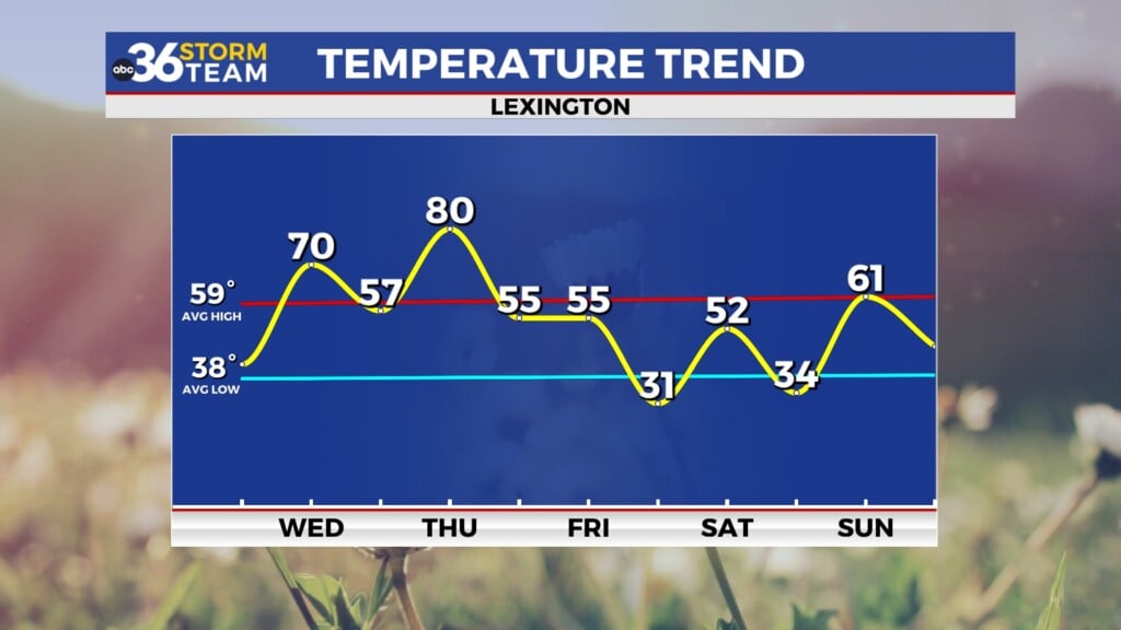
We enjoyed another quiet day of weather across Central and Eastern Kentucky on Wednesday as a broad area of high pressure over the Atlantic continued to dominate the region. Winds shifted around to the south allowing milder air to work back into the commonwealth so it was a really nice late March day from start to finish. After beginning the day in the low-40s, the combination of sunshine and the steady south breeze helped push afternoon highs all the way back into the low-70s, which is a solid 10 degrees above average for this time of the year. Our upward trend of temperatures will continue for one more day before some changes kick in.

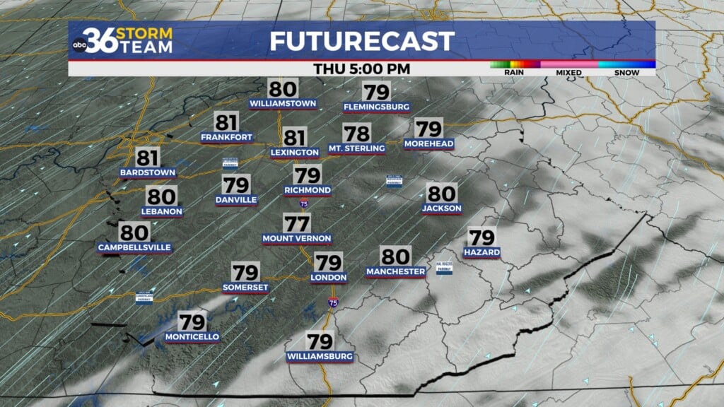
A mid-level wave of energy is set to slide through the Ohio Valley into the early hours of Thursday so a few isolates to scattered showers and storms will be possible across the northern half of the state overnight. Most of the activity should wind down and exit before lunchtime Thursday, leaving us with an unseasonably warm day. Southwest winds will crank up with gusts around 30 miles per hour, helping to push afternoon highs all the way into the low-80s in most spots, which could topple record highs for Thursday. With some sunshine returning after the morning storms, it will be another summer-like day so hopefully you can find some time to get outdoors for a bit.


A cold front will drop through the Ohio Valley Thursday night and into Friday bringing another round of showers and storms to Central and Eastern Kentucky as we end the week. The good news is our severe weather threat remains low with this system as the expected strong storms well to our north should weaken significantly as they move into our area by Friday morning. It’s another case of good timing with the loss of storm energy and instability during the night time hours working in our favor. The Storm Prediction Center still has areas along and north of I-64 in a Level 1 severe weather risk (out of 5) but that’s more of a buffer to the more favorable areas across the central part of the Ohio Valley.

It should be a damp Friday with rain and a few rumbles of thunder as the cold front pushes through the commonwealth. Our “highs” for Friday should be just after Midnight with temperatures literally falling slowly through the day. Most folks will wake up to temperatures in the 50s and 60s depending on location but by the time the sun goes down, readings should be in the upper 40s and low 50s as the cooler air pushes into the region and the rain chances wind down.

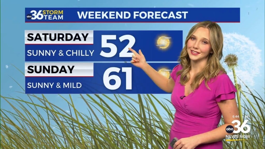
The final weekend of March looks dry and tranquil from start to finish, although it will be a bit on the cool side to start. With high pressure building in, afternoon highs will only recover into the low-50s on Saturday despite lots of sunshine but it will still be a pleasantly cool day for outdoor activities. The early mornings will be quite chilly with temperatures around freezing but once again we should see milder air make a quick return to the area as we close out the weekend. As the area of high pressure drifts eastward, a return flow will kick in on Sunday so it should be noticeably milder with afternoon highs jumping back above average into the low to mid-60s so it will be even more comfortable for any plans you have outside. More spring-like air is on tap as we close out March early next week with low-end shower chances working back into the area as afternoon highs run back into the 70s.


ABC 36 Storm Team 3 Day Forecast
Wednesday night: Breezy and mild, a few showers and storms. Lows in the upper-50s. Wind: SW 10-15 mph.
Thursday: Morning showers then windy and warm, record highs possible. Highs in the low-80s. Wind: SW 10-20 mph.
Thursday night: Mild with showers and storms returning. Lows in the mid-50s. Wind: SW 10-20 mph.