After some beneficial rain, a drier pattern kicks in for the weekend and beyond
Many locations picked up at least a half inch of rain or more and now the dry weather settles back in
It was a wet and stormy early Thursday across Central and Eastern Kentucky as pockets of moderate to heavy rain and storms rolled through the area. The favored spost for the most rainfall accumulation were parts of Southern Kentucky where much of that part of the state saw a good 1″-2″ soaking. Clouds lingered through much of the day, holding afternoon highs down into the low to mid-70s. There was definitely a good bit of lightning with the storms, which were captured nicely in pictures on social media.


Heading into Friday it should be a cloudy and potentially foggy start as the low level moisture hangs around despite the area of low pressure responsible for all the rain dissipating just to our east. By the afternoon hours, the sun should return and this will allow afternoon highs to recover into the upper 70s with a few spots flirting with the 80 degree mark. It should be another dandy night for high school football as temperatures drop into the 60s by the time the games wrap up.


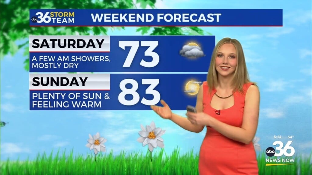
This weekend we close out September and kick off October in style as an area of high pressure over New England works back to the southwest. It appears a good chunk of the eastern part of the country will enjoy some tranquil weather which is perfect for all the fall festivals in full swing here in the commonwealth as well as the big game with Florida taking on Kentucky at Kroger Field Saturday at Noon. Expect lots of sunshine both weekend days with highs in the low 80s.

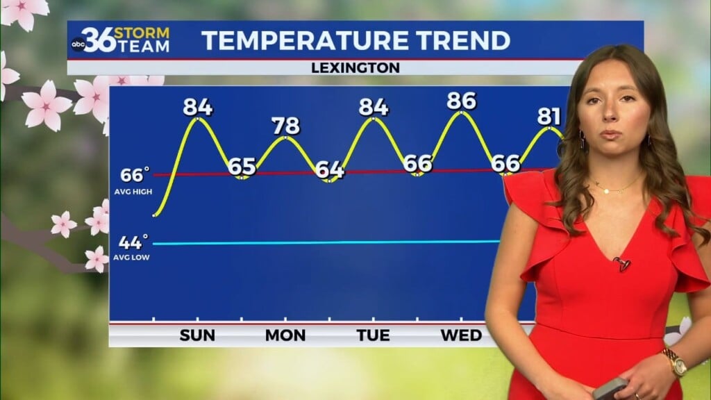
The first week of October should be fairly quiet as high pressure continues to dominate our weather. With sunny, warm days and clear, pleasant nights, it should be nice to be outdoors through the week, even if afternoon highs stay a bit above average into the mid-80s. The latest Drought Monitor shows parts of the area now in a Moderate Drought but keep in mind the reading was taken on Tuesday…before we saw any rainfall so that isn’t included in the latest update. Given the dry weather next week, we may not see much of a change, although the long term precipitation outlook has us with “near normal” rainfall by next weekend as a cold front brings showers to the area late next week.


ABC 36 HOUR FORECAST
THURSDAY NIGHT: Mostly cloudy with isolated showers, patchy fog. Lows in the upper 50s to around 60 degrees.
FRIDAY: Morning clouds, then clearing out. Highs in the upper-70s.
FRIDAY NIGHT: Mostly clear and pleasant. Lows in the upper 50s.