A few showers return as spring-like warmth remains in place
Afternoon highs will continue to be well above average to close out the week
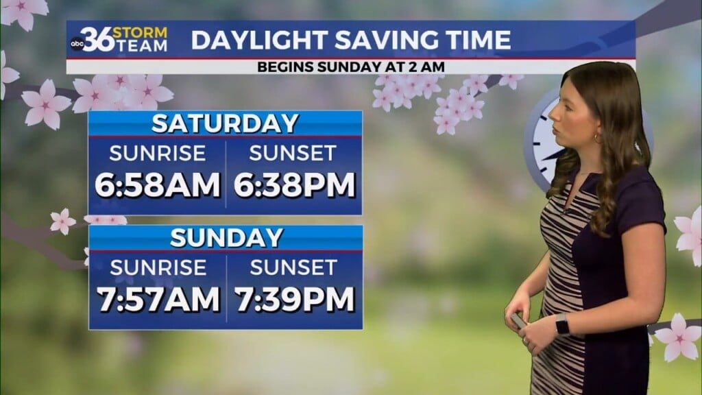
It was another amazing day of weather across Central and Eastern Kentucky on Wednesday with the combination of sunshine and a strong southwest wind pushing afternoon highs into the upper 70s, which is right around record territory for many locations. With the extra daylight in the evening after the time change this past weekend hopefully you’ve had some time in the early evening to enjoy this early taste of spring.

A weak wave of energy will slide northeastward and move across the region Thursday increasing our chance for a few scattered showers and maybe a rumble of thunder or two. We aren’t expecting anything widespread or heavy and these should be garden variety showers for the most part. The good news is that temperatures will still be well above average for mid-March despite the clouds and showers around as afternoon highs climb back into the low 70s.

We should wrap up the week in style with more sunshine and warm temperatures on Friday as our focus shifts to the dynamic storm system that is set to impact the region this weekend. At this point we are looking at two waves of rain and storms, one early Saturday and the other late Saturday afternoon and into Saturday evening. The potential for strong to severe storms exists with both these rounds as the Storm Prediction Center has parts of our area in the Level 1 risk for late Friday night and into early Saturday. Much of the data indicates the line of storms could be weakening out as it arrives early Saturday morning but there is still the potential for a few strong storms.


The main action will arrive later Saturday as a wave of low pressure rides along a frontal boundary moving through the commonwealth. All modes of severe weather will be possible along with heavy rain potential so you’ll want to be weather aware on Saturday as the Storm Prediction Center has the entire area in a Level 2 risk with their extended outlook. Right now damaging winds and even some larger hail look to be the primary threats, with the potential of a few tornadoes not off the table. One thing to watch for is the widespread severe weather outbreak expected across the Deep South using up some of the storm energy, which could possibly cut down on some aspects of the severe threat. Heavy rain is also likely, which could produce some localized flash flooding but we aren’t expecting a repeat of the flooding event we saw back in February.


Cooler air will follow suit on Sunday with a few leftover showers and temperatures backing down into the mid-50s for highs, which is actually right around average for this time in March. St. Patrick’s Day on Monday looks dry and pleasant as highs hold steady into the mid-50s. With another storm system possibly impacting the region by the middle part of next week, a southwest flow will kick in quickly by next Tuesday allowing for a nice rebound in temperatures as afternoon highs jump back into the upper 60s to around 70 degrees!
ABC 36 Storm Team 3-Day Forecast:
Wednesday Night: A few clouds and pleasant. Lows in the low-50s.
Thursday: Partly cloudy, a few isolated showers. Highs in the low-70s.
Thursday Night: Clearing skies and quiet. Lows in the upper-40s and low-50s.
Stay weather-aware as we head into the weekend, and keep up with the latest updates from the ABC 36 Storm Team!