A calm couple days leads to an active Tuesday
Meteorologist Jordan Smith has your Sunday evening forecast!
Lexington, Kentucky: Good Sunday evening everyone and Happy New Years Day! It has been a mild and dry first day of 2023 across central and eastern Kentucky with temperatures into the upper 50s to low 60s. Clouds have thickened up as the day has went on and those clouds may lead to a sprinkle or light shower on Monday with highs in the low to mid 60s. After midnight things start to get active across western and northern Kentucky with rain and storms. Here is a breakdown on how Tuesday looks to play out.

Once deeper into the morning we will see the rain and storms begin to push on into central Kentucky. It could be a wet morning commute Tuesday across many areas so you might want to add some extra time to your commute and take it slow. Our in house model shown below has a strong line of storms moving across the I75 corridor later Tuesday morning.

Waves of rain and thunderstorms will continue to move across the Commonwealth through the day on Tuesday with heavy rain, thunder, lightning, and gusty winds being possible.

After a little break into the early evening on Tuesday, another round of thunderstorms look likely late evening.

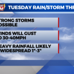
You can see we could be dealing with a lot of rain on Tuesday and that could lead to high water issues. Our in house model shows most areas near 1″ but many other models are showing higher totals so I am going with a general 1″-3″ with someone in the south and/or east maybe even exceeding that.

Another issues is going to be strong winds. Winds all day Tuesday can reach 30-40mph even without thunderstorms. With a saturated ground, that can cause some weak trees to come down and limbs to fall so power hits are possible as well.

Once past Tuesday, showers will remain into Wednesday as temperatures drop. High on Wednesday will be in the low 50s but that high will come early in the day as temperatures drop. Temperatures hit the mid to upper 20s by Thursday morning with a few snow showers or flurries possible. High on Thursday stay in the upper 30s across central and eastern Kentucky.
SUNDAY NIGHT: Clouds continue to increase temperatures in the upper 40s.
MONDAY: A good deal of clouds with high temperatures in the mid to upper 60s.
MONDAY NIGHT: Rain showers starting to develop, especially to our west. Temperatures in the low 60s.