Rain and storm chances ramp up into Tuesday
Some localized heavy rain will be possible
After a dry and warm first weekend of June with summer-like temperatures across Central and Eastern Kentucky, we started the transition back into a more active and unsettled weather pattern to begin the week on Monday. With a stationary front hanging over the Ohio Valley and a slow moving wave of energy moving from the west, we finally saw a few scattered showers and storms return to the area. Afternoon highs varied pretty significantly with a few spots into the low-80s thanks to the rain and storms moving in, while others out east spiked into the upper 80s where it stayed dry until later in the day. With plenty of moisture and warmth around, some of the activity produced some localized heavy rainfall and this will be a prelude of things to come.

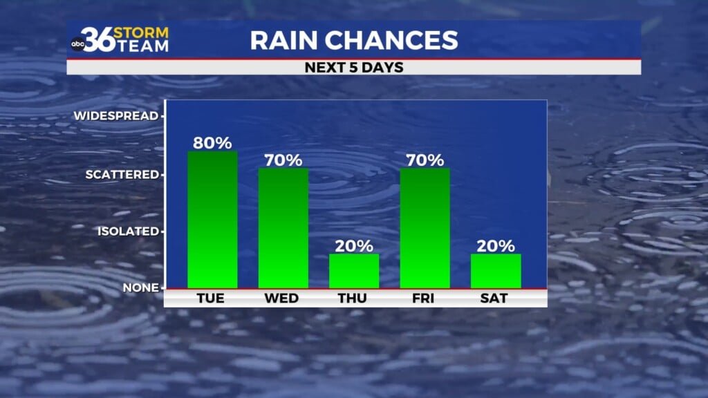
As the slow moving wave drifts eastward across the Ohio Valley, you’ll need the rain gear on occasion Tuesday. With a tropical, summer-like air mass in place and providing plenty of moisture to work with, scattered showers and storms look like a good bet through the day and these should be very efficient rain producers. Locally heavy downpours could easily drop a quick 1″-2″ in spots so we may see some brief high water issues as a result. With this in mind, a Flood Watch is out for areas west of Lexington running either side of the I-65 corridor where the higher chances exist. Temperatures will once again be held in check given the clouds and rain expected as afternoon highs reach the low-80s.


Our overall weather pattern will be more like July instead of June through the mid and late week with unseasonably warm temperatures on tap along with higher than normal humidity levels. With afternoon highs expected to be into the upper 80s to around 90 degrees along with plenty of humidity around, our “feel-like” temps will come into play with upper 90s to low 100s heat indices possible as a result. You’ll definitely need to hydrate and slow it down during the hottest part of the day. We should see a few scattered storms possible, especially Wednesday but the overall chances will be lower than what we are looking at here in the short term.


Closing out the week and heading into the weekend, a series of weakening frontal boundaries will be dropping into the Ohio Valley, keeping the chances for a few scattered showers and storms around. We are entering the time of the year where it’s a bit more challenging for the fronts to sweep through and dry us out completely, although some of the model data wants to go that route. The higher rain/storm chances look to be on Friday as the first boundary drops in with lesser chances on Saturday, which is good for any outdoor plans you may have to begin the weekend before more showers arrive by Sunday. It will remain on the warm to hot side along with a touch of humidity around so it will definitely feel like the heart of June during that window.


ABC 36 Storm Team 3 Day Forecast
Monday night: Warm with isolated storms. Lows in the upper-60s. Wind: SW 5-10 mph.
Tuesday: Scattered showers and storms, locally heavy rain possible. Highs in the low-80s. Wind: SW 10-15 mph.
Tuesday night: More showers and storms. Lows in the upper-60s to around 70 degrees. Wind: SW 5-10 mph.