A cooler start to May as Derby weekend arrives
Afternoon highs will be roughly 10 to 12 degrees below average
It was a delightful finish to April across Central and Eastern Kentucky as high pressure brought dry and tranquil conditions to the area. With plenty of sunshine around, it was a nice day to be out and about although it was a touch on the cool side as a northwest breeze helped to hold afternoon highs down into the low -60s, which is roughly 10 degrees below average for this time of the year.

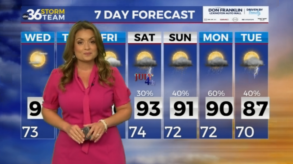
A weak boundary will drop through the Ohio Valley as we kick off the month of May, bring a few stray showers to the area for Oaks Day. Areas north of I-64 have the best chance of seeing a shower or two early before the chances spread southeastward as the day wears on. The good news is that most of the activity should be winding down early around Louisville metro so it should end up being a mainly dry Kentucky Oaks Day. Once again temperatures will be held down a bit with afternoon highs into the low-60s with a mix of clouds and sunshine later in the day and dry conditions for the big race for the fillies heading into Friday evening.

Heading into Derby Day look for more of the same as the unseasonably cool pattern stays in place over the Ohio Valley. The departing boundary from Friday will bring a reinforcing shot of cooler air into the commonwealth so temperatures may back off a few degrees as a result. With an area of low pressure passing by to our south and some weak upper level energy rotating in from the northwest, we should see a few high thin clouds maybe filtering the sunshine out a bit as afternoon highs only reach the upper 50s! You’ll want to dress for a cooler day for any Derby parties or festivities on Saturday. There is the potential a few showers may creep into our far southern counties but overall most spots will be dry. We could be looking at some frost potential into Sunday morning as temperatures fall into the mid to upper 30s so you may need to protect those plants. We’ll finish out the weekend with another pleasantly cool day as highs creep back into the low-60s.


Our overall weather pattern will become more unsettled heading into the first week of May as a series of weak frontal systems along with a few waves of low pressure bring occasional showers and storms back to the region. The chances look to be lower end early next week as afternoon highs climb back into the low-70s. We may see a better chance of some much needed rain toward the middle of next week but the data isn’t synced up on the timing and placement just yet so the best advice is to keep the umbrella handy rolling through next week. The latest Drought Monitor doesn’t paint a pretty picture with much of Southern Kentucky in a severe drought with a small section of Rockcastle, Lincoln and Casey Counties in the extreme drought category. This is typically something we would see in the late summer, not the middle of spring so we could really use some additional rain chances soon.


ABC 36 Storm Team 3 Day Forecast
Thursday night: A few clouds and cool. Lows in the mid-40s. Wind: SE 5 mph.
Friday: Partly sunny, a stray shower possible. Highs in the low-60s. Wind: W 5-10 mph.
Friday night: Scattered clouds, still chilly. Lows in the upper 30 and low-40s. Wind: N 5-10 mph.