Fabulous weather to close out February
Look for sunshine and afternoon highs in the 60s Saturday
After a chilly start to Friday with temperatures in the low 30s along with some patchy and even freezing fog, it turned out to be a delightful finish to the week across Central and Eastern Kentucky. With high pressure in control we saw plenty of sunshine across the area once the morning fog burnt off. This allowed afternoon highs to climb all the way through the 50s in most spots with a few locations reaching the 60 degree mark and beyond. This upward trend of temperatures will continue fortunately as we kick off the weekend.

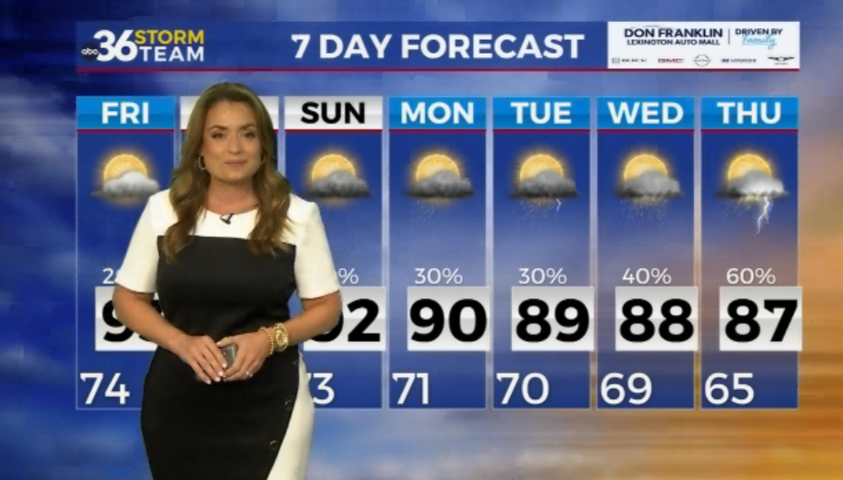
It should be a delightful close to February on Saturday as high pressure sitting to our southeast allows for unseasonably mild air to push into the commonwealth on the heels of a southwest wind. With more sunshine around, afternoon highs should surge into the low to mid-60s so it will definitely be a great day to enjoy any outdoors activities on the final day of the month. A frontal system will be drifting in from the northwest so we could see some mid to high level cloud cover slide our way before sunset but otherwise it should be a fantastic day from start to finish.


The aforementioned front will drop through the area as we flip the calendar to March on Sunday with some big changes expected, especially in the temperature department. Other than a stray shower or two during the early morning hours we should welcome March with scattered clouds and dry conditions. The biggest change will be the cooler air we’ll see on the north side of the boundary so expect temperatures to be a solid 15 to 20 degrees cooler compared to Saturday as afternoon highs only reach the mid to upper 40s. The frontal system will stall out over the region into early Monday and with a wave of energy riding along it, Monday morning could be a bit tricky as much of the data is showing the possibility of a wintry mix of precipitation as temperatures hover around the freezing mark early. This scenario could create a few issues for the morning commute so make sure to check conditions before heading out Monday morning. Temperatures will struggle to reach the upper 30s and low 40s for afternoon highs as the batch of precipitation winds down later in the day.

The first week of March looks to be unsettled across Central and Eastern Kentucky as the frontal boundary stays put over the region and several waves of low pressure ride along it. This will keep daily rain chances in play essentially all of next week. While it shouldn’t rain all day every day, you will need to keep the rain gear handy. One bit of good news is that the front will finally pull northward as the week wears on, allowing for milder air to return. Look for afternoon highs to surge back through the 60s by late next week so it will feel spring-like once again. We may have to watch out for the potential of some minor flooding issues in spots as the consistent rain on already saturated ground may cause a few problems.


ABC 36 Storm Team 3 Day Forecast
Friday night: Mostly clear and cool. Lows in the upper-30s and low-40s. Wind: S 5-10 mph.
Saturday: More sunshine and mild. Highs in the mid to upper-60s. Wind: SW 5-10 mph.
Saturday night: Mostly cloudy, a few showers possible. Lows in the upper-30s. Wind: NW 5-10 mph