Spring-like air returns as we close out February
Get set for a couple of pleasant days into the weekend
It was a messy start to Thursday across Central and Eastern Kentucky as a wave of energy brought a potpourri of weather to the area depending on where you were located. As expected, enough cold air crept as far south as the I-64 corridor early to produce some light snow, which accumulated up to a couple of inches across Northern Kentucky but mainly on the grassy areas and elevated surfaces. Farther south where temperatures stayed well into the 40s, it was an all rain event so we did see quite the temperature spread from north to south to begin the day. Once the rain exited the area, clouds lingered in spots and temperatures varied with afternoon highs creeping back into the mid to upper 40s area wide as drier air started to work into the region.

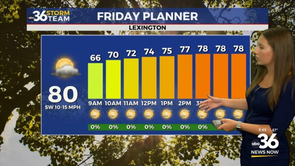
Our weather looks really pleasant for the final Friday of February as high pressure builds in from the northwest bringing a return of sunshine to the commonwealth. After a cold start to the day with morning lows close to the freezing mark, a light southwest wind combined with the sunshine will help push afternoon highs back into the upper 50s and low 60s, which is a good clip above average for the end of February. It should feel quite spring-like to say the least and this will be a prelude of things to come wrapping up the month.


We are set up for a fantastic finish to February as the pleasant, spring-like weather continues. With a slow moving frontal boundary lying just to our north, a southwest wind will stay in place for Saturday bringing additional mild air to the area. With more sunshine on tap across the board, it will be an ideal day for any outdoor activities as afternoon highs press the mid-60s here in the Bluegrass with upper 60s possible down south. You’ll definitely want to enjoy the nice beginning to the weekend as the aforementioned front will drop in on Sunday bringing clouds, low end shower chances and cooler temperatures as we flip the calendar to March. Afternoon highs may only make it into the mid-40s Sunday so expect a solid 20 degree drop compared to Saturday so it will be noticeably cooler.

This frontal boundary will stall out over the region as we roll into the first few days of March early next week with more unsettled and somewhat messy weather on the table. A wave of energy sliding along the front will bring the potential of a wintry mix of rain and snow (possibly freezing rain as well) late Sunday night and into Monday depending on where temperatures land during that time frame. At this point, readings look to be right around freezing on Monday morning so this bears watching for any potential travel issues during the early commute. As the wave moves eastward, we should see some dry times later Monday but more rain is expected to return into Tuesday as another wave heads our way and the front lifts a little farther to the north. Temperatures should be a bit milder during that window so we are looking at general rain showers as afternoon highs creep back into the 50s (and possibly higher) by the mid part of next week as the unsettled weather pattern continues.


ABC 36 Storm Team 3 Day Forecast
Thursday night: Mostly clear and cold. Lows in the low-30s. Wind: SW 5 mph.
Friday: Mostly sunny and pleasant. Highs in the upper-50s to around 60 degrees. Wind: SW 5-10 mph.
Friday night: Fair skies and quiet. Lows in the upper-30s. Wind: SW 5-10 mph