A few showers on tap into the late week
Temperatures should climb as we dry out toward the weekend
It was a breezy and mainly cloudy Wednesday across Central and Eastern Kentucky with wind gusting over 30 miles per hour during the early morning hours thanks to a stout southwest wind. The breeze helped temperatures to remain steady/slow rise so most folks were greeted with low to mid-40s out the door. With a weak frontal system dropping through the commonwealth, we did see most locations remaining dry as afternoon highs slowly climbed back into the mid-50s, which felt pretty nice for this time of the year even with the breeze around.

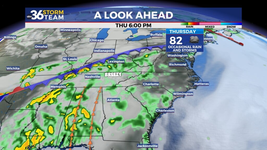
A wave of energy should ride southeastward along the frontal boundary keeping the chances of some wet weather on the table heading into Thursday. While we aren’t looking at a washout by any means, you may need the rain gear from time to time, especially early in the day. The most favorable spots for rainfall will be across Southern Kentucky where some locations could see possibly a half inch or more. While most of the precipitation should be in the liquid form, our far northern counties may get cool enough Thursday morning to mix a few snowflakes in but it shouldn’t be an issue or create any impacts. With the clouds and showers around, temperatures will be held in check across the board with afternoon highs mainly in the upper 40s with a few locations sneaking into the low 50s.


We should close out the week in style with some very pleasant weather for the home stretch of February. High pressure will build in behind the departing low and we aren’t looking at any big push of cooler air coming in. In fact, temperatures should warm up nicely with plenty of sunshine around and afternoon highs surging back into the upper 50s on Friday. The final day of February looks fabulous at this point thanks to the area of high pressure settling to our southeast and a return flow picking up, which will bring even milder air into the commonwealth. More sunshine is expected so Saturday will be the day to get out and enjoy any outdoor activities as afternoon highs jump back into the low-60s area wide.


Another frontal system will be sitting off to our northwest to begin the weekend and will drop through the Ohio Valley as we turn the calendar to March on Sunday. While our rain chances are very low with the passage of the front, it will bring clouds and noticeably cooler temperatures to end the weekend. Afternoon highs will back down into the upper 40s with a good bit of cloud cover expected. Another weak wave of energy should slide in from the northwest Sunday night and into Monday. Given the timing and temperatures Monday morning in the low to mid-30s, we could see a bit of a rain/snow mix to begin next week before temperatures moderate a bit into Monday afternoon. Look for an unsettled period of weather for the first few days of March as additional waves of energy bring more scattered shower chances to the area along with temperatures pretty close to average for this time of the year.

ABC 36 Storm Team 3 Day Forecast
Wednesday night: Mostly cloudy with a few showers/flakes north. Lows in the mid to upper 30s. Wind: NE 5 mph.
Thursday: Morning showers, drier late. Highs in the upper-40s and low-50s. Wind: NE 5 mph.
Thursday night: A few clouds and chilly. Lows in the mid-30s. Wind: NE 5 mph