Storms give way to a gradual cooling trend into the weekend
It will feel more like February in the coming days
We’ve enjoyed a nice spring-like stretch of weather across Central and Eastern Kentucky the last several days and Thursday was no exception, even with some scattered clouds and a few showers to start the day. With a wave of low pressure spinning off to our west, a steady southwest wind helped push afternoon highs into the mid to upper 60s across the board. Storms cranked up pretty quickly in the Central and Eastern Kentucky by the mid-afternoon with several Severe Thunderstorm Warnings (including Lexington and Fayette County). All of the storms produced torrential rain, some gusty winds and even some larger hail down the Bluegrass Parkway, although most of it was dime to nickel sized as it moved through the metro area.

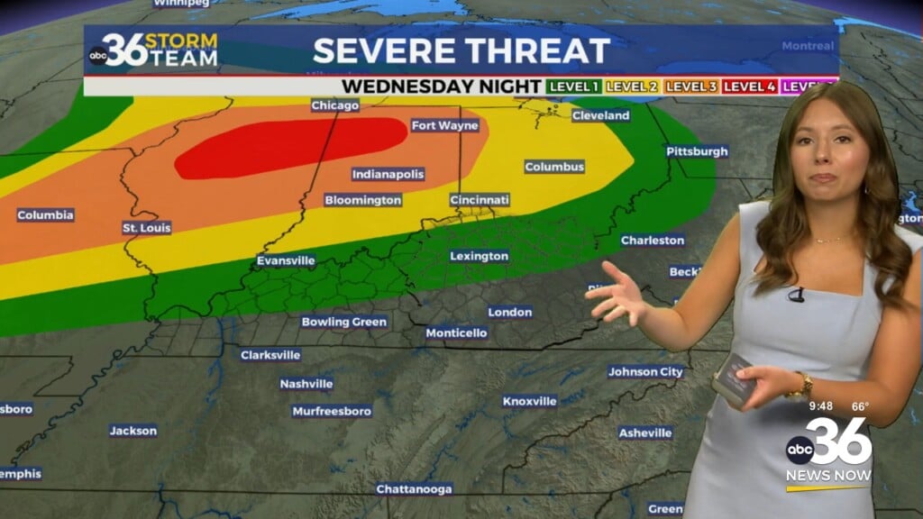
Heading into Thursday night, all modes of severe weather are possible, although the greatest tornado threat will remain to our northwest over Southern Indiana. That being said, any storms that develop will still have a damaging wind and low end tornado threat as the system moves through Thursday evening so make sure and stay weather aware. The Storm Prediction Center has areas along I-64 into the Lexington metro area in a Level 2 severe risk (out of 5), with a Level 1 risk across the rest of Central and Southern Kentucky. Make sure and stay weather aware into the overnight.

We should be in the clear literally and figuratively to close out the week on Friday with a good bit of sunshine expected across the region. Look for another breezy day with winds gusting over 30 miles per hour during the afternoon hours before diminishing late. Temperatures should start out in the low 50s Friday morning with slightly cooler air filtering in behind the front. We should see readings back bounce a few degrees into the mid to upper 50s through the afternoon so we are still looking at above average temperatures for one more day.


Heading into the weekend, a weak wave of energy will pass to our south keeping our rain chances at a minimum for Saturday. This should allow for a little more sunshine across the area. Couple that with lighter winds and it should be a pretty decent late February weekend day as afternoon highs sneak into the low-50s in many spots. Some upper level energy looks to rotate through the Ohio Valley by Saturday night and into Sunday ushering in a brief reality check with colder air returning to the commonwealth. A few light rain showers will be possible and with temperatures dropping into the upper 20s by Sunday morning, we’ll likely see scattered snow showers for the second half of the weekend. With a northwest flow in place, the most favorable area for the persistent snow showers on Sunday will be the mountains of Eastern Kentucky, where a light coating may be realized in a few spots but the overall impact will be low. It will definitely feel like winter again with afternoon highs back down into the mid-30s.

Stubborn cloud cover may now linger into Monday with the northwest flow aloft and some of the data is showing a few spotty snow showers into Eastern Kentucky to kick off next week. Again it should amount to much and it’s just a reminder that we are still in February. The biggest impact will be the cold temperatures as afternoon highs only reach the low to mid-30s. We should see a pretty quick rebound as milder in begins to return on Tuesday as some sunshine works back in and high temperatures run toward the 40 degree mark. Another frontal boundary will approach from the northwest by the middle of next week so a southwest flow ahead of it should warm us up even more with afternoon highs back into the low-50s on Wednesday as our rain chances increase once again into the second half of next week.

ABC 36 Storm Team 3 Day Forecast
Thursday night: Breezy with scattered storms, ending late. Lows in the upper 40s and low-50s. Wind: SW 10-15 mph.
Friday: Mostly sunny and windy. Highs in the mid-50s. Wind: W 15-20 mph.
Friday night: A few clouds and chilly. Lows in the mid-30s. Wind: W 5-10 mph.