Milder temperatures are on the way into the mid-week
A legitimate strong storm may be on the horizon
It was a very foggy start to President’s Day across Central and Eastern Kentucky with visibilities less than 1/4 of a mile at times early along with a few slick spots on the roadways thanks to temperatures sneaking below freezing for a period of time. Fortunately with it being a holiday, there was less traffic during the morning so that kept issues at a minimum. The rest of Monday ended up being pretty decent with a few scattered clouds and afternoon highs into the mid-50s, which felt pretty good for the middle part of February.

With high pressure to our southeast, look for a return flow with winds out of the south to kick in on Tuesday helping to bring even milder air back into the Ohio Valley. Even with some expected cloudiness around, afternoon highs should jump back into the low 60s across the board so more unseasonably mild air is on tap. A weak frontal system will be laying off to our northwest and responsible for the expected clouds but we are looking at a dry day from start to finish.

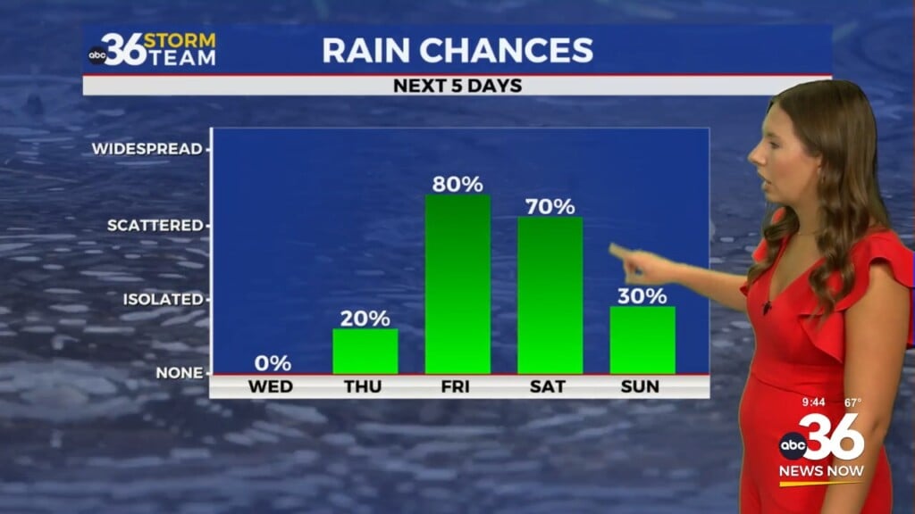
The mid to late week looks very spring-like across the area as our weather gets a little more active during that window. A wave of low pressure should pass us by to the north on Wednesday and this may squeeze out a stray shower or two across the northern half of the state but overall things look dry. Winds will begin to crank up out of the southwest with gusts 25 to 30 miles per hour, which will bring additional mild air to the commonwealth. Once again we’ll see more clouds than sunshine, but afternoon highs will still roll back into the mid to upper 60s so it should feel really good outdoors. For the first time in quite some time, a legitimate strong storm threat bears watching for late Thursday as a stronger area of low pressure drags a frontal system through the Ohio Valley. Temperatures should surge into the upper 60s and low 70s for afternoon highs Thursday ahead of this boundary as strong southwest winds stay cranked up so we’ll see a touch of spring for sure.

Some of the data is indicating a few strong storms on the table heading into Thursday night and the Storm Prediction Center has the Ohio Valley highlighted in their extended severe weather outlook during that time frame. This is something that bears watching closely over the next few days and given that we’ve not seen any legitimate severe weather potential for quite some time, it’s good to get back into that mindset by reviewing your severe weather safety plan as we rapidly head toward the spring severe weather season here in a few short weeks.

Once that system passes through, the data is split heading into the weekend with some models indicating a secondary wave of low pressure sliding through late Saturday and into Sunday, which would bring a few more rain showers and the possibility of a few snowflakes as the system exits the area. This doesn’t appear to be a major weather maker at this point but of more significance will be some cooler/colder temperatures returning for a few days. Afternoon highs should drop back closer to average into the upper 40s on Saturday before we get a quick reminder that it is still the winter season with temperatures struggling to get out of the 30s for highs into early next week thanks to a northwest flow aloft.

ABC 36 Storm Team 3 Day Forecast
Monday night: A few clouds, not as cold. Lows in the upper-30s and low-40s. Wind: S 5 mph.
Tuesday: Mostly cloudy but milder. Highs in the low to mid-60s. Wind: S 5-10 mph.
Tuesday night: More clouds and breezy. Lows in the mid-50s. Wind: S 10-15 mph.