Summer warmth continues into the mid-week
More dry weather is on the way Wednesday so enjoy it while it lasts
It was another picture-perfect early June day across Central and Eastern Kentucky on Tuesday. Sunshine dominated the skies once again with afternoon highs climbing well into the mid-80s, making it feel more like mid-summer than the start of meteorological summer. In fact it was our warmest day so far here in 2025. The only minor hiccup was a bit of elevated wildfire smoke from blazes burning in western Canada, which subtly filtered the sunshine. While it didn’t impact air quality, it did help create another round of stunning sunrises and sunsets—something we’ve seen frequently this week.

Another Summer-Like Day Wednesday Before Changes Arrive
High pressure remains firmly in control for now, setting us up for one more solidly summer-like day on Wednesday. South winds at 10–15 mph will continue ushering in warm air, with highs reaching the mid to upper 80s once again. Most areas will stay dry and sunny, but later in the day, we’ll need to keep an eye on the northwest corner of the region for a stray shower or storm trying to sneak in as a frontal boundary begins its slow approach. Enjoy the warmth while you can—changes are brewing for the end of the week.

Stormy Stretch Likely Late Week with Heavy Rain Potential
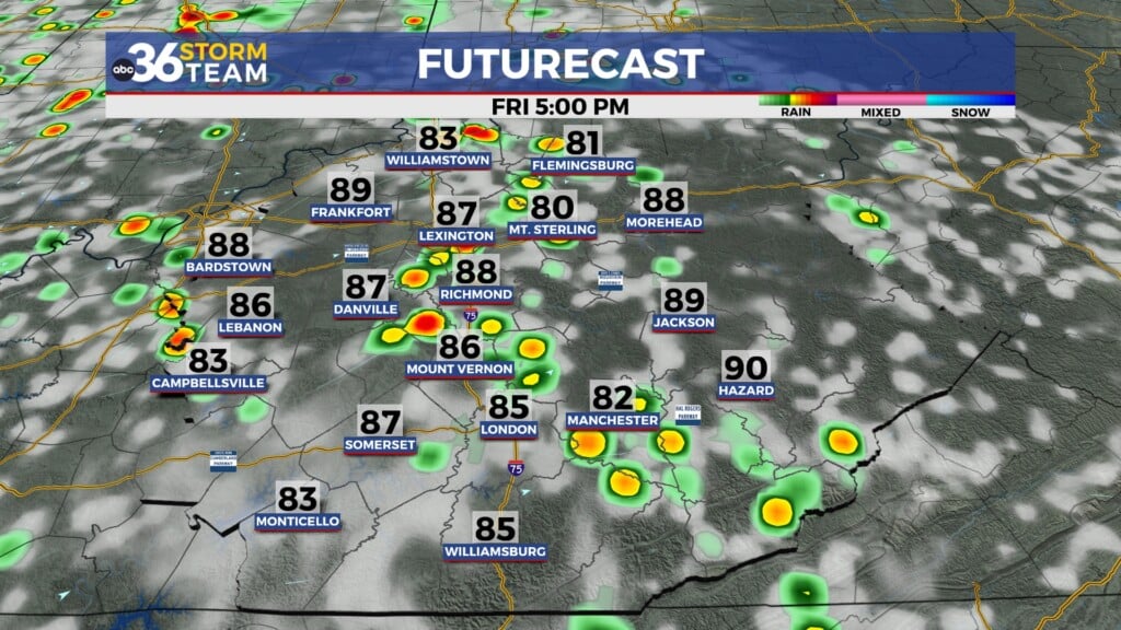
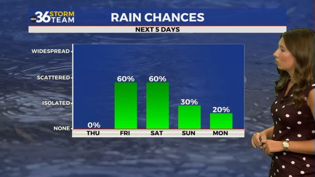
That approaching front will settle in across the Ohio Valley late this week and stall out over Kentucky, opening the door to an extended period of unsettled weather. Starting Thursday and lasting into Saturday, waves of energy will ride along the front, triggering rounds of showers and thunderstorms across the region. Some of these storms could bring pockets of moderate to heavy rainfall, and rainfall totals of 1″ to 2″ (locally higher) are likely through Saturday. Given the moisture-rich air and the potential for storms to “train” over the same areas, localized flooding will need to be monitored, especially in low-lying or flood-prone spots.
Additionally, with daytime heating and increased instability, a few stronger storms capable of gusty winds or hail can’t be ruled out. The exact timing and intensity of any severe threat is still uncertain, but we’ll keep a close eye on the setup.


Weekend Outlook: Rain Chances Linger but Not a Total Washout
By the weekend, the front may sag just far enough south to reduce—though not eliminate—rain chances, especially on Saturday. You’ll still want to keep the umbrella handy if you have outdoor plans, but there should be some dry stretches to work with. With added clouds and occasional rain, highs will be more seasonable, hovering around 80 degrees, which is right on par for early June. Another round of energy could try to bring more rain early next week, but some models hint at a brief break in the action by Sunday and Monday.

Tuesday Night: Mostly clear and mild. Lows in the mid-60s. Wind: S 5-10 mph.
Wednesday: Mostly sunny, breezy and warm. Highs in the mid to upper 80s. Wind: SW 10-15 mph.
Wednesday Night: Fair skies, warm and muggy. Lows in the upper-60s. Wind: SW 5-10 mph.