Highs in the 80s make a return appearance here in early April
A strong south wind will push afternoon highs into the low 80s the next few days before our storm chances ramp up
It was a nice start to the first week of April across Central and Eastern Kentucky with some initial sunshine giving way to clouds and a few light showers across the northern and southern half of the commonwealth. Despite a weak wave of energy moving through with the clouds, afternoon highs surged into the low 70s in most spots and we should do even better heading into Tuesday. Quick weather history…Today (Monday) marks the 49th anniversary of the “Super Outbreak” of April 3-4, 1974, a generational tornado event that impacted a large part of the Ohio Valley and the Mid-South. This was the event that inspired me to become a meteorologist. There were 148 tornadoes in 13 states over a 24 hour period. Here in Kentucky we had 26 confirmed tornadoes with 71 deaths statewide…31 of those were in Brandenburg, the county seat of Meade County with a population of only 1,800. I went back to Brandenburg to produce a 30 minute special for the 25th anniversary back in 1999 and as you can imagine the painful memories still cut very deeply there.

With a strong south wind and eventually some sunshine breaking out following some morning clouds, Tuesday looks like an awesome spring day with unseasonably warm temperatures expected. Afternoon highs should surge either side of the 80 degree mark with just an isolated shower or storm possible, mainly during the morning hours along and north of I-64. The bottom line is that most locations should be dry so take advantage of some nice spring weather.

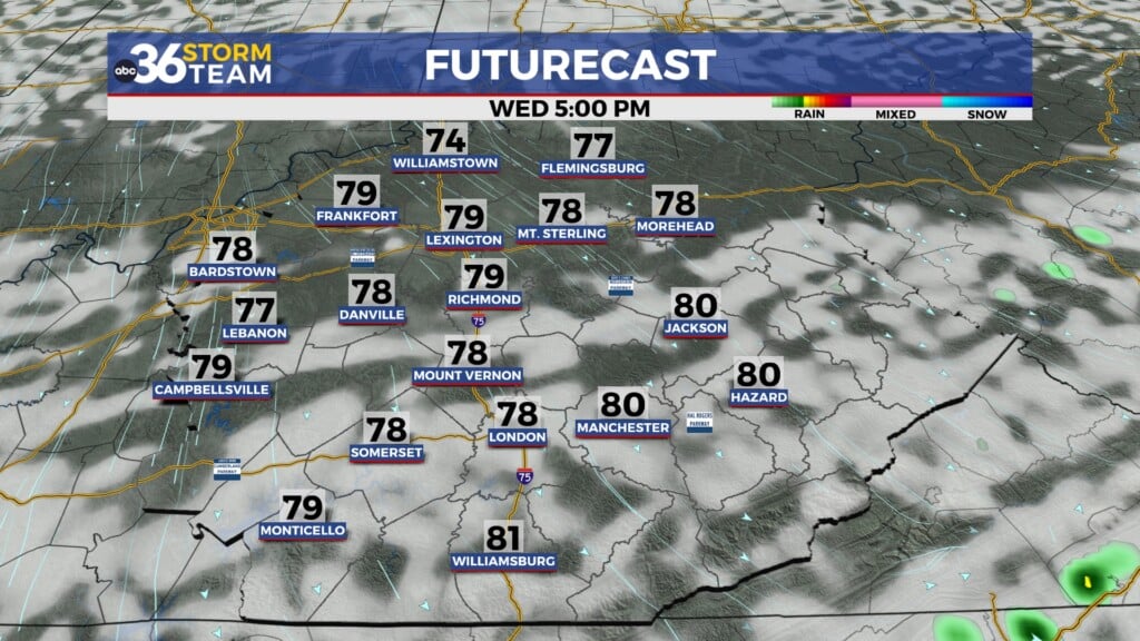
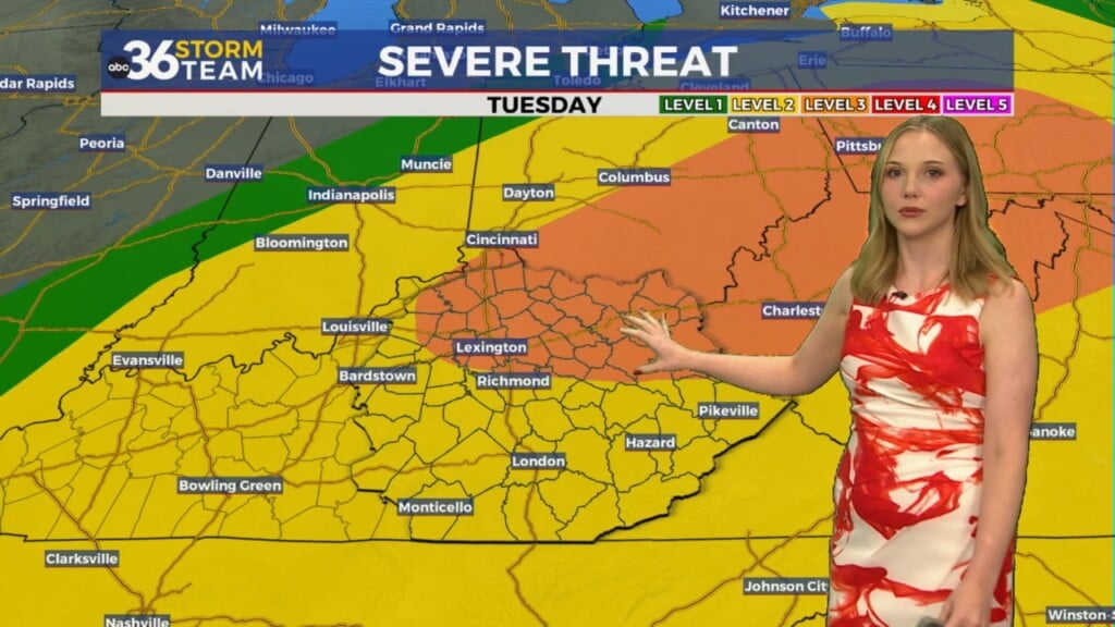
A cold front will make its way slowly into the Ohio Valley on Wednesday, which will gives us another chance at reaching 80 degrees for afternoon highs, but also set the stage for a few strong to severe thunderstorms around the area. The Storm Prediction Center expanded the Level 2 risk (out of 5) to included all of Central and Southern Kentucky (originally it was the I-64 corridor and points north) with the Level 1 risk across Southeastern Kentucky. This is to account for the slower expected arrival of the frontal boundary digging through the region. The good news is that the better chance for a few spin-up tornadoes will be north of the Ohio River with damaging winds being our biggest concern. Of course we’ll continue to monitor this over the next couple of days.

The front will stretch out and slowly drop through the commonwealth into early Thursday and that slow movement should keep a few showers around for the morning hours on Thursday. It will definitely be “cooler” behind the front with highs in the upper 50s, which is just a few degrees below average for this time of year.

There is better news heading into Easter weekend as much of the data is now supporting a dry holiday weekend with conditions looking very pleasant on Easter Sunday. While it may be a touch cool for sunrise services with temperatures in the mid-40s, the afternoon looks very pleasant as highs work back toward 70 degrees with dry conditions.

ABC 36 HOUR FORECAST
MONDAY NIGHT: Scattered clouds and breezy. Lows in the mid-50s.
TUESDAY: Early clouds, then breezy and warm with a stray storm. Highs in the low-80s.
TUESDAY NIGHT: Breezy and mild, mainly dry. Lows in the upper-60s.