More unseasonably mild air for February on the horizon
A few additional showers and storms will be on the horizon but temperatures will be well above average mid-week with highs in the 70s
After a nice February weekend across Central and Eastern Kentucky we saw a dreary President’s Day as a frontal boundary and a wave of low pressure cruised through the area. Most of the rain was gone by early afternoon and despite some lingering clouds, a southwest wind helped push afternoon highs into the mid-50s with milder air where the sun came out to our west. Speaking of the sun, we had some delightful sunrise/sunset shots over the weekend with plenty conditions for this time of the year.


Heading into Tuesday, a weak area of high pressure should settle into the Ohio Valley briefly with more in the way of sunshine and afternoon highs into the mid to upper 50s. It will be a bit breezy with west winds occasionally gusting from 25 to 30 miles per hour but temperatures will still be a few degrees above average for this time in February.

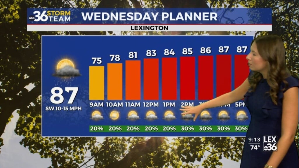
Yet another surge of spring-like air will be headed into the Ohio Valley through the mid and into the late week. A warm front to our south will slide to the north Tuesday night and into Wednesday, bringing a few showers and storms but also very warm air for February. Afternoon highs are set to climb into the low 70s Wednesday as a strong southwest wind pushes the warm air into the region. It shouldn’t be a wash out with the best chances for rain and storms Tuesday night and into Wednesday…and then another round Wednesday night and into Thursday.
It appears that Thursday will be mainly dry as a lot of the moisture will be concentrated around the area of low pressure to our northwest. As a result, it may be a mainly dry day with highs in the mid-70s! Both Wednesday and Thursday we should have temperatures at or near records for highs so that’s something we’ll keep an eye on.

One good thing about the rain and storms being scattered and coming in a few waves is that our overall rain totals for this week should be in the half inch to isolated 1″ readings through the end of the week. Given how saturated the ground is and with many of the area rivers and streams still running high, this is positive news. However, additional shower chances will be possible from time to time into the weekend.

ABC 36 HOUR FORECAST
MONDAY NIGHT: A few clouds and cool. Lows in the low-40s.
TUESDAY: Mostly sunny, breezy and pleasant. Highs in the mid to upper 50s.
TUESDAY NIGHT: Clouds increase with rain returning, rising temps. Lows in the low 40s early climbing into the low 50s by daybreak.