Sunshine returns across Kentucky as summer like heat builds toward the weekend
After a few morning showers Wednesday, much warmer temperatures and isolated storm chances build into Kentucky by the weekend
Morning Showers Fade As Sunshine Returns
Central and Eastern Kentucky started off Wednesday morning with plenty of cloud cover and a line of scattered showers moving through the area. Those showers have now pushed farther east, and many communities are already beginning to see sunshine return this afternoon.
Some stubborn cloud cover is still hanging around across southern and southeastern Kentucky, but overall conditions are steadily improving as the cold front responsible for the morning rain continues to move out of the region.
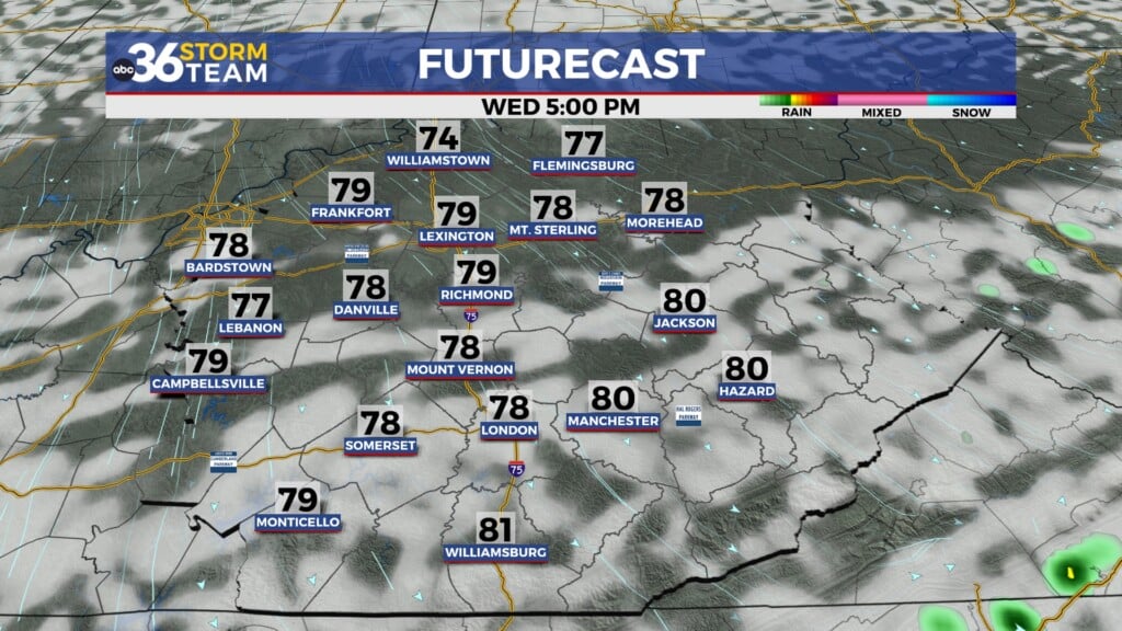
Afternoon highs today are expected to climb back into the mid to upper 70s across much of the area, although breezy west-northwest winds gusting between 20 and 25 mph will make it feel a bit cooler at times.
A Few Isolated Showers Still Possible This Afternoon
While most of the area is expected to stay dry for the remainder of today, southern and southeastern Kentucky could still see an isolated shower or two develop later this afternoon and evening.
By this evening, any leftover showers and cloud cover are expected to clear out quickly as cooler and drier air settles into the region behind the front.
Chilly Tonight With A Slight Frost Concern
As skies clear overnight and winds become lighter, temperatures are expected to drop quickly across parts of Kentucky tonight.
Many communities will fall into the low to mid 40s overnight, and some of the colder valleys and rural locations could briefly dip into the upper 30s by early Thursday morning.
Because of those cooler temperatures, anyone with sensitive plants outdoors may want to bring them inside or cover them overnight just to be safe.
Cooler But Beautiful Weather Returns Thursday And Friday
Thursday is shaping up to be another fantastic spring day across the Bluegrass State.
High pressure building back into the Ohio Valley will bring lots of sunshine and dry weather, although temperatures will be a bit cooler compared to earlier this week. Afternoon highs Thursday will top out in the upper 60s and low to mid 70s across the region.
Friday looks equally pleasant as temperatures rebound back into the mid and upper 70s with continued sunshine. There is a slight chance for a few isolated showers Friday afternoon as another weak disturbance approaches the region, but many areas will likely stay dry.
Summer-Like Heat Arrives This Weekend
As we head into the weekend, Kentucky is preparing for a major warm-up that will make it feel much more like summer than spring.
A warm and humid air mass will move into the Ohio Valley beginning Saturday, sending temperatures soaring into the mid and upper 80s this weekend. Some locations could even reach the 90-degree mark by Sunday and Monday.
At the same time, increasing humidity and daytime heating could help spark scattered showers and thunderstorms, especially Saturday afternoon and evening. While widespread severe weather is not expected at this time, a few stronger storms could produce heavy downpours, gusty winds, and frequent lightning.
If you plan on spending time outside this weekend, whether by the pool, at a ballgame, or at any outdoor events, make sure to keep an eye on the forecast for any isolated storm development.
Storm Chances Increase Again Early Next Week
Sunday currently looks mostly dry and very warm, but rain and thunderstorm chances are expected to increase again by Monday night into Tuesday as another stronger system approaches the Ohio Valley.
Forecast models show increasing moisture and humidity early next week, which could support heavier rainfall and stronger thunderstorms by Tuesday.
ABC 36 Storm Team 36 Hour Forecast
Wednesday Night
Clearing skies and cooler temperatures overnight with lows in the low to mid 40s. A few colder spots could briefly dip into the upper 30s.
Thursday
Sunny, dry, and slightly cooler with afternoon highs in the upper 60s to low 70s.
Thursday Night
Mostly clear and cool with overnight lows in the 40s.