Sunny Skies and Comfortable Days Ahead for Central Kentucky
Cool nights, sunny afternoons, and a gradual warm-up heading into late week.
A Record-Breaking Start to Sunday
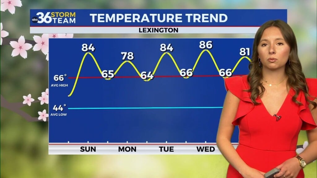
It has been a picture-perfect weekend across central and eastern Kentucky, with Sunday bringing highs in the mid-70s and plenty of sunshine. The real headline, though, came early this morning in Lexington, where temperatures dipped to 45 degrees, breaking the previous record low of 47° set back in 2017.
Another Chilly Night Ahead
Don’t put the jackets away just yet—tonight could bring another round of record-breaking chill, with lows expected to fall back into the mid-40s under clear skies. Rural areas and valleys may feel even colder, so if you’re heading out this evening or early Monday morning, you’ll want the extra layer. By the afternoon, though, it’s back to short sleeves as highs return to the 70s.
Sunshine Sticking Around
This stretch of weather is being driven by high pressure sliding across the Ohio Valley, which is keeping things dry, clear, and comfortably cool at night. Patchy fog may form in some river valleys before sunrise, but otherwise, Monday looks like a near repeat of Sunday: sunny skies, low humidity, and afternoon highs in the mid-to-upper 70s.
Warming Trend Later This Week
The dry pattern sticks around through the week, and with winds shifting out of the south by midweek, temperatures will gradually climb. Highs are expected to reach the low to mid-80s by Thursday and Friday, while overnight lows remain comfortable in the upper 40s and 50s. This warming trend should carry us right into next weekend, still with very little chance of rain.
ABC 36 Weather Team’s 36-Hour Forecast
Sunday Night: Clear and cool. Record lows possible in spots. Lows: mid-40s.
Monday: Sunny and pleasant. Highs: mid-70s.
Monday Night: Mostly clear and chilly again. Lows: upper 40s.