Snow transitions to rain as a warming trend begins
Light snow early before a switch to rain
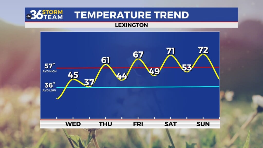
A weak system is moving through the Bluegrass region, bringing light snow to start before a transition to rain later in the day.
Early on, much of the snow may struggle to reach the ground due to dry air near the surface, but as moisture increases, light snow and flurries will become more common. Any accumulation will be minimal, generally just a light dusting.
As temperatures rise through the morning, the snow will change over to light rain by early afternoon. Clouds will begin to clear out later in the day, leading to improving conditions.
High temperatures will vary across the region, with mid 40s in eastern Kentucky and mid 50s toward the southwest.
Quiet and cool tonight
Skies will become mostly clear overnight with light winds in place. Temperatures will fall into the mid to upper 30s.
Milder air continues to build
A gradual warm-up will take hold heading into the end of the week. Another weak system may bring a few light rain showers, mainly across northern parts of the Bluegrass.
Temperatures will climb into the 60s, marking a noticeable shift back toward spring.
Warm weekend with next system ahead
The warming trend continues into the weekend, with highs reaching the upper 70s to near 80 degrees.
Another cold front is expected to approach late in the weekend, bringing the next chance for showers and possibly thunderstorms. The exact timing is still uncertain, but it will be the next system to watch as temperatures eventually trend cooler again early next week.