Severe storm and flood threats for the week ahead
Meteorologist Jordan Smith has your Sunday evening ABC 36 Storm Team forecast
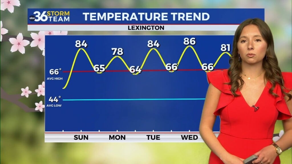
LEXINGTON, Ky. (ABC36 NEWS NOW): Good Sunday evening everyone, most everyone has been dry skies today and temperatures in the muggy upper 70s to low 80s. But there has been some scattered showers and storms out there impacting some areas. Our pattern is about to crank it into high gear as we have multiple rounds of strong to severe storms and flooding rains tomorrow (Monday) – Thursday. Let’s get straight to it with Mondays forecast. We will start the day into the low to mid 60s with showers and thunderstorms already developing across the area.

They will continue into the afternoon with highs in the mid to upper 70s.

Scattered storms will then carry us into Monday evening and night.

It is not going to rain all day Monday by any means and there will be plenty of dry times, but we are going to have to deal with showers and storms all day. Also, good news is that there is no severe threat for Monday as these are just general thunderstorms. But we still got to be on guard for issues in the form of local flash flooding with repeat thunderstorms. The severe weather chances increase into our Tuesday with a “SLIGHT RISK” (level 2/5) already out for the entire state on the SPC’s day three outlook. That very well may get bumped up for parts of our area by Tuesday.

ALL modes of severe weather are possible on Tuesday in the form on damaging winds, large hail, and isolated tornadoes. The threat is there for more additional flash flooding issues as well. A scattered storm or two is possible during the morning hours, but it looks like late morning into early afternoon will bring us the best chance at strong to severe storms.


A few showers and storms would then carry us into Tuesday afternoon/evening.

Wednesday is likely the bigger severe threat of the two with a “potential” significant severe weather event on tap. The SPC has issued another “SLIGHT RISK” (level 2/5) for the entire state again. This is outside of their traditional outlooks which normally only goes to day 3, but they have went ahead and highlighted our entire region for day 4 because the ingredients are so strong for severe weather.

Here are some tips to know to get you prepared.

As of now, timing looks to be the second half of Wednesday into the night. Exact timing and details will be ironed out in the coming days so please stay up to date on-air and online with your ABC 36 Storm Team! #kywx